
ASHEVILLE, N.C. (828newsNOW) — After days of hot, dry weather and drought concerns, Buncombe County is preparing for a wet and windy change as the remnants of Tropical Storm Arthur sweep across Western North Carolina Thursday night into Friday.
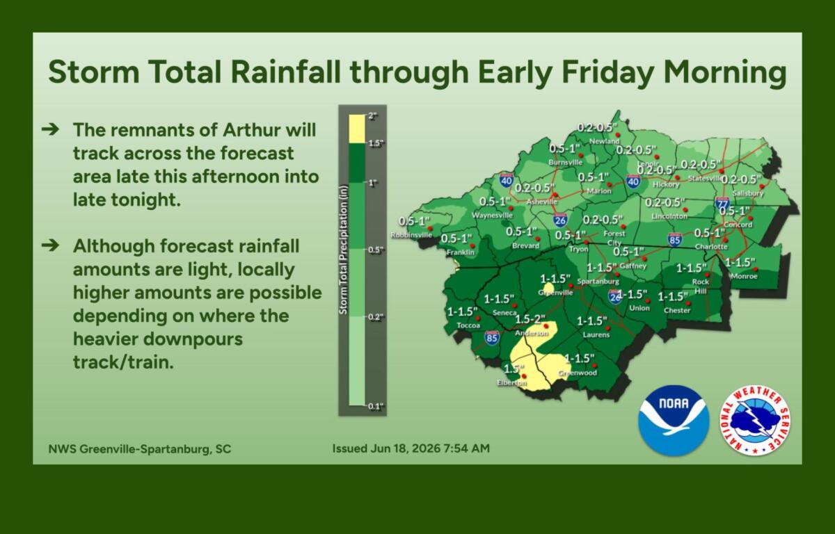
County officials said the system is expected to bring about an inch of rain to Buncombe County, with locally higher amounts possible in heavier bands. While widespread flooding and prolonged power outages are not expected, emergency managers are monitoring the storm’s potential for downed tree limbs, isolated power disruptions and brief periods of heavy rain.
“We’re not anticipating major impacts at this time, but residents should remain weather aware,” Buncombe County officials said in a weather update Wednesday evening.
The National Weather Service in Greenville-Spartanburg said Arthur’s remnants will interact with a cold front as they move across the region, creating the potential for widespread rain, embedded thunderstorms and occasional strong wind gusts.
Forecasters say a few storms could become severe Thursday afternoon and evening, with damaging wind gusts posing the greatest threat. While the risk remains low, meteorologists have not ruled out an isolated tornado.
Rainfall totals of 1 to 3 inches are possible across parts of Western North Carolina, depending on where the heaviest bands develop. The National Weather Service has placed the area under a slight risk for excessive rainfall, though officials said uncertainty about where the heaviest rain will fall has prevented the issuance of a flash flood watch.
The rain arrives at a welcome time for many communities across the Carolinas. Drought conditions have persisted across portions of the region, and weather experts say the moisture should provide relief to dry soils and vegetation.
Carolina Weather meteorologists described the rainfall as “much needed,” noting that some locations could receive 2 to 3 inches where the heaviest bands set up.
Before the rain arrives, however, strong southwest winds are expected to develop Thursday afternoon. Wind gusts between 25 and 45 mph are possible, especially along higher elevations and ridge tops.
The combination of gusty winds, hot temperatures and exceptionally dry vegetation prompted the National Weather Service to issue a Fire Danger Statement for parts of North Carolina’s Piedmont on Thursday.
In Asheville, showers and thunderstorms are expected to develop Thursday afternoon before becoming more widespread Thursday night. The city could see temperatures near 90 degrees before the arrival of cooler air behind a cold front Friday.
Friday’s forecast calls for lingering morning showers, followed by clearing skies and lower humidity. High temperatures are expected to reach the low 80s.
Dry weather is expected Saturday before typical summertime afternoon shower and thunderstorm chances return Sunday and continue into next week.
Buncombe County officials encouraged residents to sign up for emergency alerts by texting “BCReady” to 67283 or registering at BuncombeReady.org to receive notifications about severe weather, flooding, wildfires and other emergencies.