
ASHEVILLE, N.C. (828newsNOW) — A mix of winter weather conditions blanketed the Asheville area Thursday morning, with snow, ice, gusty winds and bitter cold creating hazardous conditions across much of the Western North Carolina mountains.
Snow was expected to taper off through the day, but cold temperatures and strong winds were forecast to persist, according to the National Weather Service office in Greenville-Spartanburg, South Carolina.
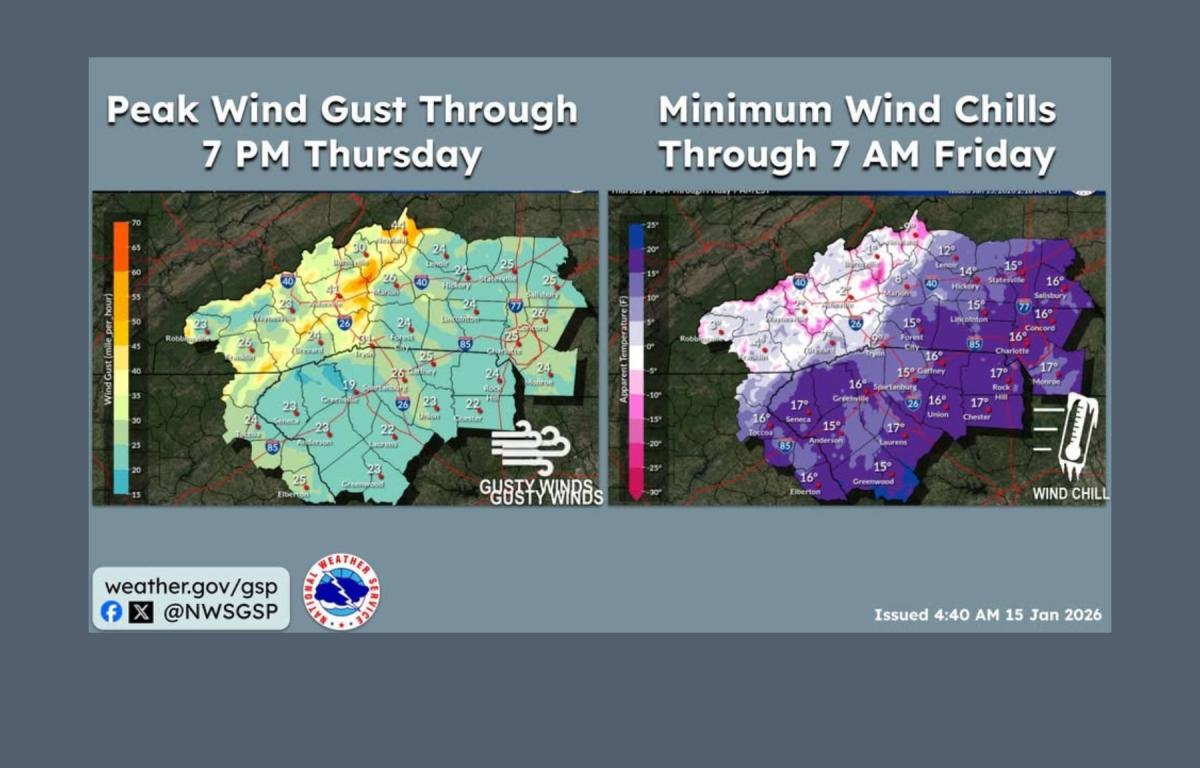
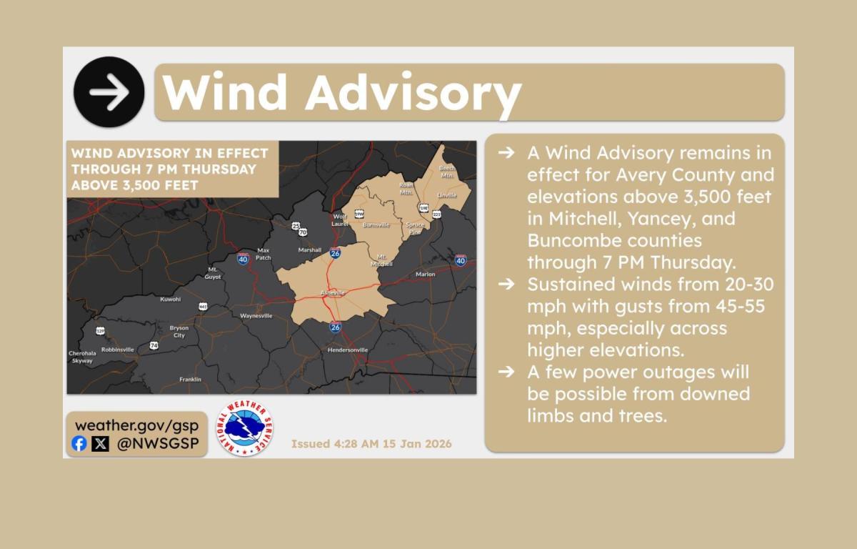
A Wind Advisory remained in effect through 7 p.m. Thursday for the higher elevations of Buncombe, Yancey and Mitchell counties, as well as all of Avery County. Sustained winds of 20 to 30 mph were expected, with gusts reaching 45 to 55 mph, particularly at higher elevations. The weather service warned that downed trees and limbs could cause isolated power outages.
A Cold Weather Advisory was also in effect until 7 a.m. Friday for elevations above 3,500 feet. Temperatures were forecast to drop into the teens and single digits early Thursday and remain below freezing throughout the day. Lows Thursday night were expected to fall into the lower teens to single digits again. Combined with strong winds, wind chill values were expected to range from minus 5 to minus 15 degrees, increasing the risk of frostbite or hypothermia with prolonged exposure.
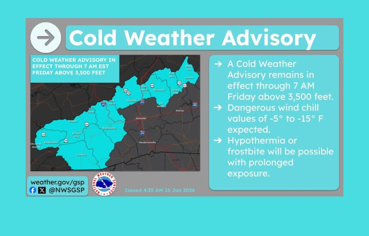
Forecasters said peak wind gusts Thursday could be strong enough to down trees and power lines, while exposed skin could develop frostbite in a short period of time at higher elevations.
Light snow accumulations were possible across the North Carolina mountains late Friday night into early Saturday, primarily at higher elevations, which could lead to minor travel issues. Confidence remained low for additional snow east of the mountains late Saturday night into Sunday, though snow chances have increased slightly along the southeastern edge of the forecast area.
The weather service said another surge of cold air is expected early next week, and a Cold Weather Advisory may be needed for parts of the mountains by Tuesday.
In the Asheville area, Thursday’s forecast called for mostly sunny skies with a high near 27 degrees and wind chills as low as minus 2. Northwest winds of 16 to 20 mph were expected, with gusts up to 39 mph. Temperatures were forecast to drop to around 10 degrees overnight.
Friday is expected to be mostly sunny with a high near 48, followed by a chance of rain late Friday night into early Saturday. A slight chance of snow is possible Saturday night, with colder conditions returning Sunday and Sunday night.