
ASHEVILLE, N.C. (828newsNOW) — The Asheville area has a history of moderate earthquakes. Did you know the largest was a magnitude 5.2 event in 1916 that was centered near Skyland?
The quake was felt across a wide area, including South Carolina, Tennessee and Virginia.
Asheville lies within the East Tennessee Seismic Zone, a region known for seismic activity, though not typically strong enough to cause major damage. The most recent event — a magnitude 4.1 earthquake Saturday centered near Greenback, Tennessee — followed that trend. It wasn’t powerful enough to cause destruction, but it did get people’s attention.
How strong is a 4.1 earthquake?
A 4.1 earthquake releases a substantial amount of energy, though it’s generally not considered a damaging earthquake.
According to an article on the USGS website, “A magnitude 1.0 earthquake is roughly equivalent to the energy release from an explosion of about 70 pounds of TNT (a mid-sized construction site blast), a magnitude 2.0 earthquake is similar to an explosion of 1 metric ton of TNT, and a magnitude 4.0 earthquake is approximately equivalent to the energy release from an explosion of 1,000 tons of TNT (a small nuclear blast).”
The severity of an earthquake is generally proportional to the amount of seismic energy it releases, according to the Earthquakes Canada website. Seismologists use a magnitude scale to express this energy release.
Here are the typical effects of earthquakes in various magnitude ranges:
- Less than 3.5: Recorded on local seismographs, but generally not felt.
- 3.5-5.4: Often felt, but rarely cause damage.
- Less than 6.0: At most slight damage to well-designed buildings. Can cause major damage to poorly constructed buildings over small regions.
- 6.1-6.9: Can cause damage to poorly constructed buildings and other structures in areas up to about 62 miles across where people live.
- 7.0-7.9: “Major” earthquake. Can cause serious damage over larger areas.
- 8.0-8.9: “Great” earthquake. Can cause serious damage and loss of life in areas across a wide area.
- 9: Rare great earthquake. Can cause major damage over a large region more than 620 miles across.
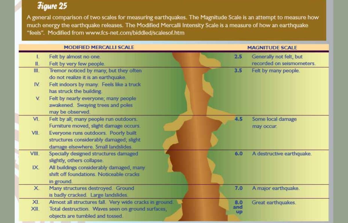
Saturday’s 4.1 earthquake fell within the range of “light” or “minor” earthquakes.
According to volcanodiscovery.com, North Carolina has had 34 quakes of magnitudes up to 4.1 so far this year:
- 1 quake above magnitude 4
- 1 quake between magnitude 3 and 4
- 16 quakes between magnitude 2 and 3
- 16 quakes below magnitude 2 that people normally don’t feel.
In 2024, North Carolina ha had 117 quakes of magnitudes up to 3.0:
- 7 quakes above magnitude 3
- 71 quakes between magnitude 2 and 3
- 39 quakes below magnitude 2 that people normally don’t feel.
The United States Geological Survey’s data showed 21 quakes hit North Carolina in 2023. The largest one was a magnitude 3.2 quake that hit 2.5 miles north-northwest of West Canton on June 4. That was followed later that day by a 2.2-magnitude one with an epicenter 1.9 miles north of West Canton.
Notable Western North Carolina earthquakes:
- 1926 Mitchell County: A 5.2 magnitude earthquake occurred in Mitchell County on July 8, 1926.
- 1957 Buncombe County: A 3.7 magnitude earthquake was recorded in Buncombe County on July 2, 1957.
- 1957 Jackson County: A 4.0 magnitude earthquake occurred in Jackson County on November 24, 1957.
- 1957 McDowell County: A 4.1 magnitude earthquake occurred in McDowell County on May 13, 1957.
- 1969 Glenville: A minor earthquake with a noise like a sonic boom awakened many in Glenville on December 13, 1969.
- 1970 Boone Area: A similar earthquake occurred in the Boone region on September 9, 1970.
- 1981 Henderson County: A 3.5 magnitude earthquake occurred in Henderson County on May 5, 1981.
- 2020 Sparta: A 5.1 magnitude earthquake occurred near Sparta on August 9, 2020.
- 2025 May 10: A 4.1 magnitude earthquake was felt in Asheville and Western North Carolina on May 10, 2025, with reports indicating it was felt as far east as Charlotte and north as Washington D.C.