
ASHEVILLE, N.C. (828newsNOW) — More evacuations have been ordered as wildfires in Polk County spread to more than 6,000 acres.
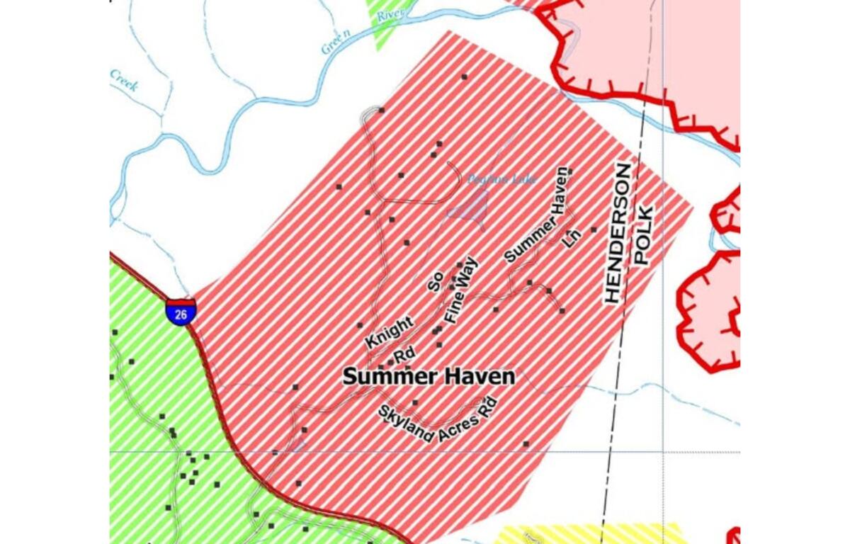
Henderson County Emergency Management and the North Carolina Forest Service issued an evacuation order Tuesday night for the Summer Haven community in Henderson County. The order includes Macedonia Road east of Interstate 26, Skyland Acres Road, Knight Road, Summer Haven Lane and S. Fine Way.
An emergency shelter has been set up at the Henderson County Parks & Recreation Athletics and Activities Center at 708 South Grove St. in Hendersonville.
CLICK HERE TO SEE INTERACTIVE FIRE MAP FOR HENDERSON COUNTY
Polk County evacuations include:
Black Cove Fire
- Green River Cove Road addresses from 1091 to 1528
- Lady Slipper Trail
- Big Hungry Road
- Spurgeon Cove Lane
- English Heifer Cove Road
- Deer Trail
- Scarlets Mountain Road
Deep Woods fire
- 5079-7265 Holbert Cove Road
According to the North Carolina Forest Service, the Black Cove Fire is now 3,046 acres and 0 percent contained, the Deep Woods fire is 2,923 acres and 0 percent contained and the Fish Hook Fire is 199 acres and 72 percent contained.
The Table Rock Fire in South Carolina had grown to 2,293 acres and the Persimmon Ridge Fire had grown to 996 acres by Wednesday night.
Evacuation orders have been issued for the Big Hill community, Dolly Masters Road, Glady Fork Road and Lake Honda and Happy Acres communities in Transylvania County.
Transylvania County Emergency Management has opened a shelter at the Transylvania Recreation Department at 1078 Ecusta Road in Brevard.
Connestee Fire Rescue and other first responders are working on a plan to help to try to defend the Connestee Falls community and surrounding areas.
“Some nearby neighborhoods along East Fork Road were told to evacuate. These communities are just north of the wildfires and have no natural or artificial fire breaks,” Connestee Falls General Manager/COO Jim Whitmore said.
The North Carolina Forest Service has started creating a firebreak in the area south and west of East Fork Road between the evacuated neighborhoods and East Fork Road, Whitmore said.
“They have heavy equipment and personnel from surrounding fire departments and some of Connestee Falls maintenance staff. The goal is to create two firebreaks, the one they are manually cutting in and then the roadway system of East Fork Road and Walnut Hollow,” he said.
Out of an abundance of caution and in the interest of public safety, officials at DuPont State Recreational Forest have closed several trails and roads, effective immediately.
The following forest trails and roads are closed until further notice:
- Reasonover Creek Trail
- Turkey Knob Trail
- Joanna Road
- Poplar Hill Loop
- Twin Oaks
- Table Rock Trail
- Three Lakes Trail
- Mine Mountain Trail
- Fawn Lake Loop
- Corn Mill Shoals
- Grassy Creek Trail
- Conservation Road
- Fawn Lake Road
- Continental Divide Tract (area of DuPont State Recreational Forest near Green River Road and the S.C. border)