
BUNCOMBE COUNTY, N.C. (828newsNOW) Local leaders are urging many residents who live near rivers to self evacuate and get to a safe place before Hurricane Helene makes its way to Western North Carolina.
Buncombe County
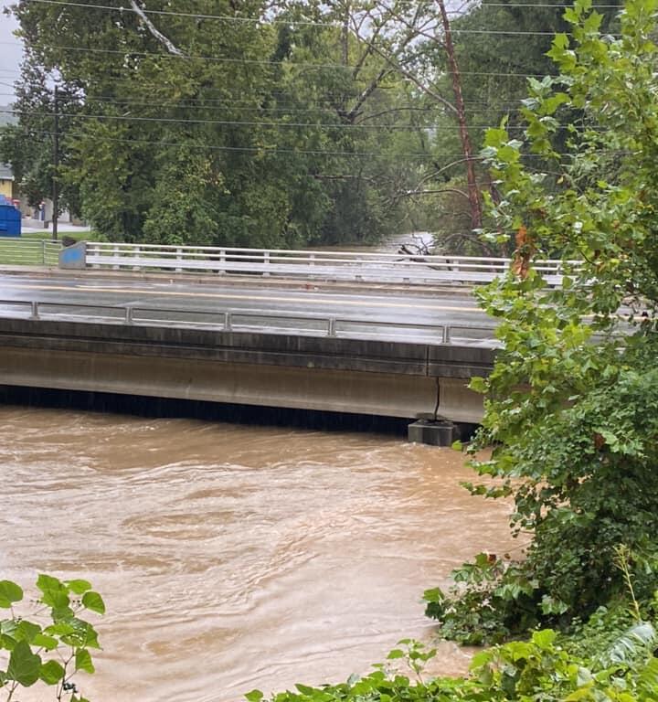
Buncombe County officials warn residents of potentially “catastrophic and historic” flooding heading toward certain areas of the county.
Major impacts are expected along the French Broad and Swannanoa Rivers.
Residents, businesses, visitors, and employees in Fletcher and Biltmore Village near the rivers should self-evacuate before anticipated crests overnight Friday and into Saturday morning.
“Flooding is expected to rival and/or surpass flooding from the 1916 flood,” officials said on Thursday.
HURRICANE HELENE: STORM UPDATES, SHELTER INFO & MORE
“If you are in an impacted area, you should leave now,” said Emergency Services Director Taylor Jones. “It’s possible we may get to a point where our crews will not physically be able to perform rescues. We cannot emphasize how much you should take this seriously.”
First Baptist Church Swannanoa has opened community sheltering, and Trinity Baptist Church will open a shelter at 3 p.m. Thursday.
“Buncombe County is working to develop GIS mapping of the projected impacts, but those in the Biltmore Village and Fletcher areas along the river should plan to evacuate now,” officials warned.
828 ROAD REPORT: WNC CLOSURES AHEAD OF HURRICANE HELENE
Buncombe County Government administrative offices and buildings, including the landfill and transfer station, will be closed on Friday, Sept. 27. The Buncombe County Courthouse also will be closed.
Buncombe County officials held a press briefing earlier Wednesday. CLICK HERE to watch.
Buncombe County will hold a virtual media briefing at 4 p.m. It will be streamed live on Facebook at www.facebook.com/buncombegov.
McDowell County
McDowell County Emergency Services is issuing an urgent notification to residents living near creeks, rivers, and streams that are at high risk of flash flooding due to the impending impact of Hurricane Helene. The forecast predicts an additional 10-15 inches of rainfall on already saturated ground, significantly increasing the likelihood of life-threatening floods in these areas.
In addition, Duke Energy has provided a critical update regarding Lake James. Based on current forecasts and conditions, Lake James will begin spilling today and is expected to reach or exceed 110.0 feet by Friday afternoon, which is 10 feet above the full pond elevation. This will be the highest lake level ever recorded at Lake James. Lake residents should prepare for flooding conditions and closely monitor lake levels. Residents living along lakes and rivers, or in flood-prone areas, are urged to exercise caution, follow directions from emergency managers, and stay informed of changing weather and streamflow conditions. High water conditions may also create navigational hazards.
Lake level information is available through Duke Energy at duke-energy.com/lakes, by calling 800-829-5253, or via the Duke Energy Lake View mobile app. Updates will be provided as conditions change.
Shelter Information:
- Location: Glenwood Baptist Church
155 Glenwood Baptist Church Rd. Marion, NC - Opening: Thursday, September 26, 2024, at 9:00 AM
For those needing transportation assistance, please contact us at 828-652-3241.
What You Need to Know:
- This forecasted rainfall is in addition to the rain already received, increasing the potential for severe flooding.
- Flash flooding can occur suddenly, especially during the night when visibility is limited.
- Roads may become impassable, and emergency response could be delayed or unavailable in certain areas.
Residents in flood-prone areas should prioritize their safety by relocating to higher ground or with family and friends if possible.
Madison County
Residents and business owners in the area of Downtown Marshall are strongly encouraged to make preparations to evacuate before they are isolated by flooded roads coming in and out of town. The same encouragement continues for residents of Rollins Road and Island Road.
Madison County Emergency Management will be opening a shelter at 4:00 p.m. at the wellness center behind Madison Early College (5734 US 25/70, Marshall). For now, residents and businesses should make immediate preparations to evacuate to higher ground. The current forecast for the river crest in Marshall is 19 feet. This would be the third largest flood on record, after 1916 (22 feet) and 1902 (21 feet). While the crest is not expected until Friday, we expect roads to become impassable sooner.