
ASHEVILLE, N.C. (828newsNOW) — Another hot and humid day is on tap as a sweltering heat wave continues across Western North Carolina. The National Weather Service said some relief might be coming by way of scattered rain and thunderstorms this afternoon.
A Heat Advisory remains in effect through 8 p.m. for portions of the North Carolina Foothills, Piedmont and mountain zones, along with Upstate South Carolina and parts of northeast Georgia.
High temperatures are expected to reach the upper 90s to near 100 degrees in lower elevations and the low 90s in mountain valleys. With dewpoints in the upper 60s to mid-70s, heat indices are forecast to range from 105 to 109 degrees, particularly in counties like Caldwell, Burke, McDowell, Rutherford and Polk.
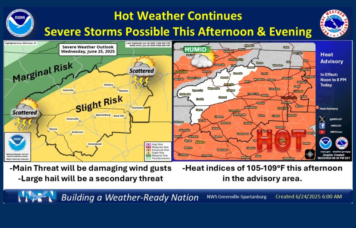
Scattered to numerous thunderstorms are likely to develop Wednesday afternoon and evening as the strong upper-level ridge over the region begins to weaken. Some storms may become severe, with damaging wind gusts the primary threat, though large hail is also possible. The Storm Prediction Center has placed the region under a Slight Risk for severe weather and a Marginal Risk for excessive rainfall.
Meteorologists warn that a volatile atmosphere is developing, with significant instability in place. Model soundings show strong potential for damaging microbursts, as well as slow-moving storms that could lead to isolated flash flooding in low-lying areas.
Storms are expected to begin forming between 3 and 6 p.m., particularly along the I-85 corridor and in the I-26 mountain region, though some models suggest a later onset closer to 5 to 7 p.m. Showers and storms may persist into the evening and possibly overnight.
While relief from extreme heat is expected later in the week as the ridge continues to break down, humid conditions and elevated storm chances will persist into early next week.