



ASHEVILLE, N.C. (828newsNOW) — With another hurricane approaching the Southeast, the prospect of heavy rain this weekend is bringing back troubling memories for people across Western North Carolina.
But forecasters say the weather setup is very different from the one that produced Tropical Storm Helene’s catastrophic flooding two years ago.
When Helene struck in September 2024, days of heavy rain had already soaked the mountains. Rivers and streams were rising, and the ground was saturated before the storm brought even more rain.
This time, Western North Carolina is heading into the weekend after a relatively dry stretch.
At Asheville Regional Airport, just 2.92 inches of rain has fallen since Sept. 1, compared with a normal 4.99 inches for the same period, according to the National Weather Service. That’s a deficit of 2.07 inches.
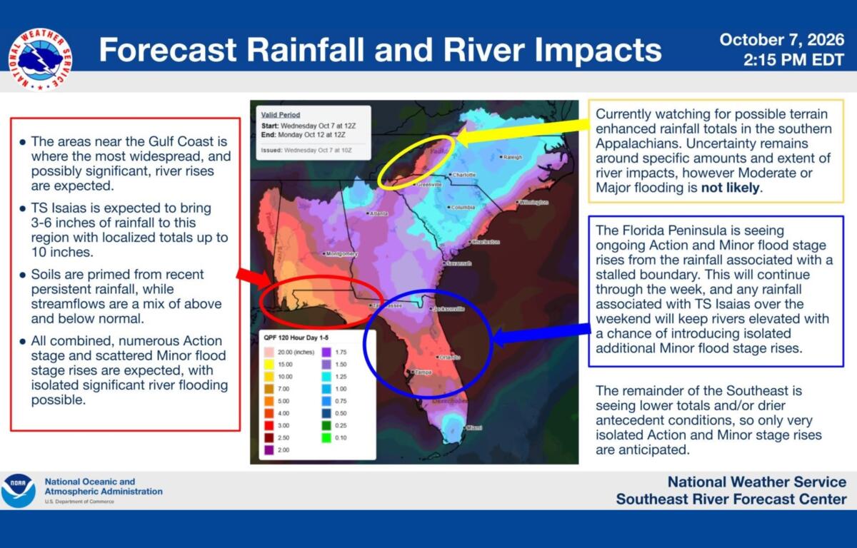
That difference matters as moisture from Hurricane Isaias moves into the mountains Saturday and Sunday.
The National Weather Service says the recent dry weather could help limit the flooding potential. But forecasters are still watching for locally heavy rainfall, particularly along the southeast-facing slopes of the mountains.
Why Helene was different
Helene didn’t arrive in Western North Carolina on its own.
A separate weather system had already dumped several inches of rain across the mountains before Helene moved inland Sept. 27, 2024.
At Asheville Regional Airport, nearly 14 inches of rain fell between Sept. 25 and 27, including rainfall from the earlier weather system and Helene. Some mountain communities received considerably more.
That earlier rain left the ground saturated and rivers already rising in some areas. When Helene brought even more rain, the flooding became catastrophic.
Communities including Swannanoa, Marshall, Biltmore Village and Asheville’s River Arts District were devastated. Landslides and washed-out roads cut off entire neighborhoods and communities.
Forecasters aren’t seeing that same setup this time.
When will the rain arrive?
Asheville should see two more relatively pleasant days before the weather changes.
Thursday will be sunny and warm, with a high near 81 degrees. Friday will be partly sunny, with a high around 76.
Rain chances increase Saturday afternoon, with showers likely after 2 p.m. The high will be near 66 degrees, and southeast winds could gust as high as 28 mph.
Saturday night looks to be the wettest period, with a 90% chance of rain and thunderstorms possible after 11 p.m.
Showers and possibly a thunderstorm will continue Sunday, when the chance of rain is 80%. The high will be near 72 degrees.
Rain chances should decrease Sunday evening.
The National Weather Service says the greatest potential for excessive rainfall is Saturday night into Sunday, although forecasters are still working to determine where the heaviest rain will fall.
Some forecasts suggest 1 to 3 inches of rain across parts of Western North Carolina, with locally higher amounts possible along the Blue Ridge Escarpment. Those projections could change depending on Isaias’ track and how the storm interacts with other weather systems.
Flooding remains possible
While this isn’t the same weather setup as Helene, that doesn’t mean there’s no risk.
Heavy rain falling over a short period can still cause flash flooding, even when the ground has been relatively dry.
And some areas of Western North Carolina remain more vulnerable because of damage left behind by Helene.
The storm reshaped stream channels, damaged riverbanks and destabilized hillsides. That damage could make some places more susceptible to flooding or landslides during heavy rain.
Forecasters are particularly watching the headwaters of the French Broad and Savannah river basins, where moist air moving up the mountain slopes could produce heavier rainfall.
The National Weather Service says rainfall estimates remain uncertain. More detailed computer models expected Friday should give forecasters a better idea of where the heaviest rain might fall and whether flood watches will be needed.
For now, residents are encouraged to keep an eye on the forecast, especially those living near streams, rivers, steep slopes or areas still recovering from Helene.
Western North Carolina is likely headed for a wet weekend, and localized flooding remains a concern. But unlike September 2024, the mountains aren’t already soaked from days of heavy rain before the tropical moisture arrives.