
ASHEVILLE, N.C. (828newsNOW)
The storm system that spawned a tornado in Black Mountain last month also produced two tornadoes in Jackson County that merged into one twister, the National Weather Service confirmed Thursday.
The Black Mountain tornado, rated an EF0, had an estimated peak wind speed of 85 miles per hour as it traveled along a 2.47-mile path that was about 30 yards wide about 12:15 a.m. May 9, the NWS said.
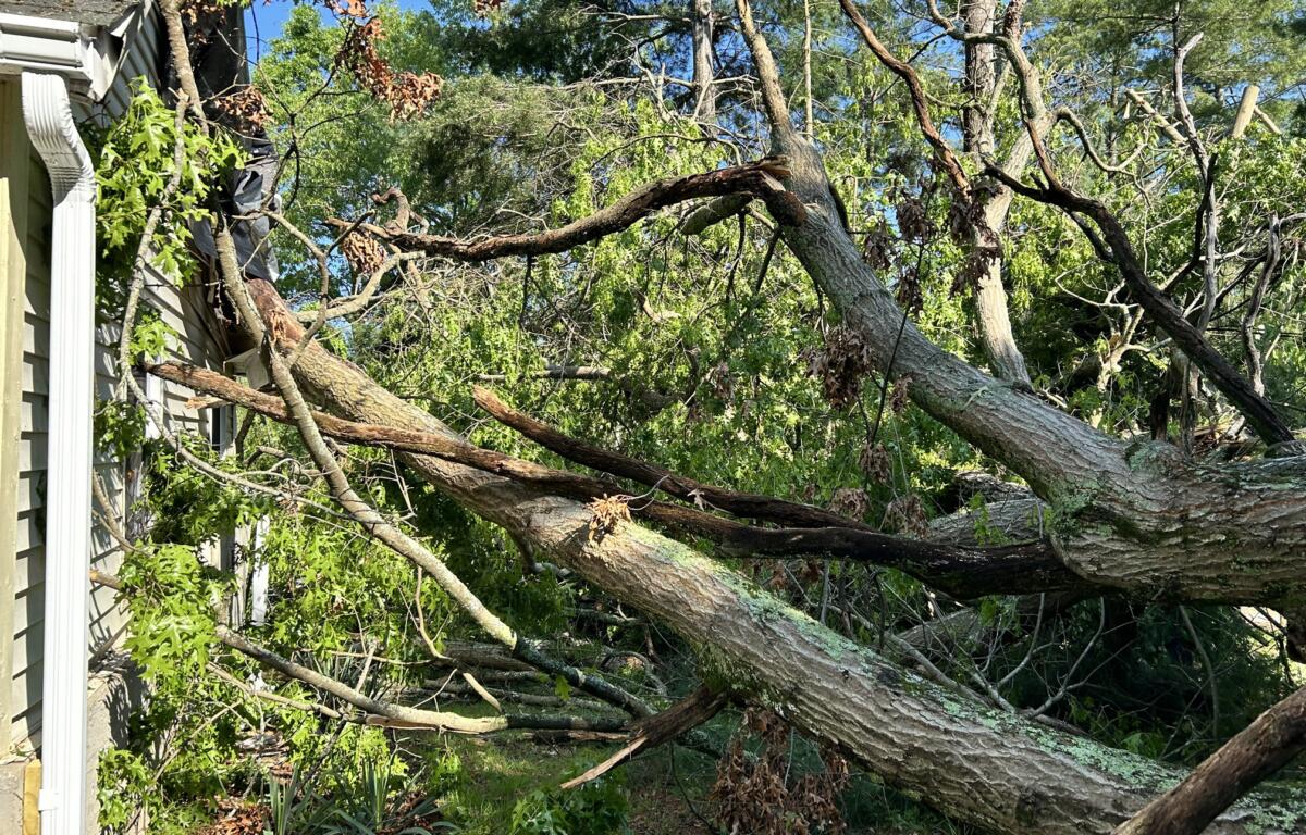
The tornado touched down along North Fork Road, moved southeast across Allen Mountain and across the Black Mountain Golf Course. The most concentrated damage occurred from Laurel Avenue north of downtown, where multiple trees were uprooted along with numerous large limbs snapped, the NWS said. Several homes sustained damage from falling trees. A communications tower at the Black Mountain fire station was also toppled. The tornado lifted along East State Street.
WEATHER: POSSIBLE TORNADO CAUSES DAMAGE IN BLACK MOUNTAIN
The damage survey released by the NWS on Thursday added two tornadoes in the Glenville area of Jackson County to the storm report from May 9.
According to the NWS, the first was an EF2 with peak winds estimated at 115 miles per hour. The path was 9.54 miles long and 400 yards wide. The twister was estimated to have started about 12:15 a.m. about 4 miles north of Ellijay and ended at 12:26 a.m. about 4 miles south/southeast of Tuckasegee.
The survey summary said the tornado touched down in a heavily wooded area in the Cowee Mountains just east of Pumpkintown near the Macon County line. It ascended a ridge near Kirby Knob and rapidly strengthened as it descended through Cullowhee Gap and crossed Tilley Creek Road, the NWS report said. The tornado quickly reached peak intensity of EF2 with 115mph winds just east of Tilley Creek Road.
Approximately 80 percent of the trees in this swath were either snapped or uprooted, the report said.
The tornado weakened to a high-end EF1, snapping or uprooting many trees as it passed just below Moss Knob. It then turned southeast, remaining in a remote and heavily wooded area as it continued to down numerous trees between Pine Knob and Low Ridge with the damage path focused near Whiterock Creek. Several trees were uprooted where the tornado crossed White Rock Road near Cullowhee Mountain Road, the report said. The twister then entered the Cullowhee Forest community, where numerous trees were downed along Walking Stick Trail as the tornado paralleled Hunter Jim Creek.
After exiting Cullowhee Forest, the tornado crossed the West Fork Tuckasegee River and N.C. 107 just below Trout Creek Road. High-end EF-1 damage was once again noted as the tornado crossed N.C. 107 and ascended a ridge, where a stand of trees received modest damage with approximately 60 percent of the trees felled, the NWS report said.
The tornado then passed through the northern portion of the Sims Valley community on the south side of Trout Creek. Numerous trees were downed along the mountainside with several trees brought down in the Trout Creek Campground, the report said.
The tornado turned southeast one more time before dissipating in a wooded area near Big Ridge.
The tornado traveled across rugged terrain with limited or no vehicle access to the path of damage. The NWS said high-resolution satellite imagery, drone imagery and personal photographs were used to help fill data gaps and estimate start/end points of the twister.
SIGN UP FOR OUR NEWSLETTER and BREAKING NEWS ALERTS from 828newsNOW.com
The second tornado was about 200 yards wide and 1.54 miles long with estimated peak winds of 105 mph, making it an EF1.
The NWS said it started at 12:23 a.m. about 4 miles south/southwest of Tuckasegee and ended at 12:25 p.m. about 4 miles south of Tuckasegee.
According to the survey summary, the brief tornado touched down in a wooded area just below Lake Glenville near Shoal Creek Mountain Road, crossed Shoal Creek Mountain Road twice where the road takes a sharp hairpin turn. The tornado reached a peak intensity of 105 mph in this area, the report said.
The tornado crossed N.C. 107 and moved northeast, where it ascended Pilot Mountain, passing very close to the summit. A narrow and focused swath of downed trees was documented where the tornado crossed Big Pilot Mountain Road. The tornado descended Pilot Mountain into the Simms Valley community.
This tornado occurred at the same time as the main tornado was passing through the Trout Creek area. The second tornado turned north as it moved toward Trout Creek and dissipated as it merged with the broader area of rotation associated with the main tornado.
NWS Greenville-Spartanburg said Jackson County Emergency Management provided drone imagery of the damage path and residents of the Simms Valley community provided additional damage pictures that helped determine the presence of a second concurrent tornado that crossed Pilot Mountain.