
ASHEVILLE, N.C. (828newsNOW) — Fall officially begins at 2:19 p.m. Monday, but residents of Western North Carolina can expect conditions more like late summer, according to the U.S. National Weather Service in Greenville-Spartanburg.
Forecasters say high temperatures will be several degrees above normal, with scattered showers and thunderstorms possible over the mountains and foothills through Wednesday. Rain and storms are likely across much of the region Thursday and Friday.
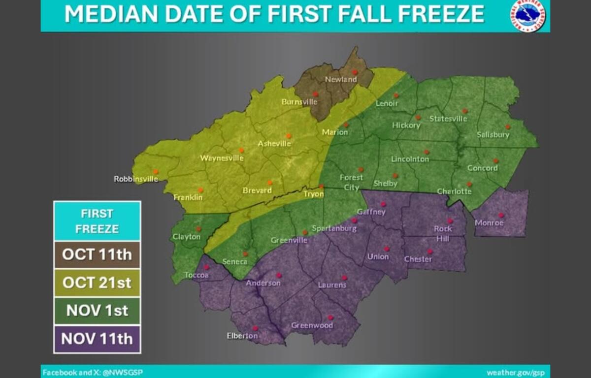
The first fall freeze, defined as when surface air temperatures reach 32 degrees Fahrenheit or lower, typically occurs around Oct. 21 in Asheville, the National Weather Service said.
Officials also reminded residents that Daylight Saving Time ends at 2 a.m. Sunday, Nov. 2. The change provides a timely opportunity to replace batteries in smoke detectors, carbon monoxide detectors and NOAA weather radios.
This week’s forecast:
- Today: Mostly sunny, with a high near 82. A 20 percent chance of showers and thunderstorms this afternoon.
- Tonight: Patchy fog and otherwise, partly cloudy, with a low around 59.
- Tuesday: Partly sunny, with a high near 84. Widespread dense fog, mainly before 9 a.m. A 30 percent chance of showers and thunderstorms, mainly after 5 p.m.
- Tuesday night: Patchy fog after 4 a.m. Otherwise, mostly cloudy, with a low around 61. Chance of precipitation is 30%.
- Wednesday: Partly sunny, with a high near 83. Patchy fog before 10 a.m. A 30 percent chance of showers and thunderstorms, mainly after 3 p.m.
- Wednesday night: Mostly cloudy, with a low around 64. A chance of showers and thunderstorms, then showers likely after 11 p.m. Chance of precipitation is 60%.
- Thursday: High near 78. Chance of precipitation is 80%.
- Thursday night: Low around 62. Chance of precipitation is 80%.
- Friday: Mostly cloudy, with a high near 75. Chance of precipitation is 60%.