




ASHEVILLE, N.C. (828newsNOW) — Hot and humid weather is sticking around Western North Carolina, with a heat-health alert issued for several counties as temperatures climb into the 90s this week.
The North Carolina Department of Health and Human Services issued heat-health alerts for parts of the region Tuesday through Thursday, with heat indexes expected to reach the mid-90s in some areas.
Graham County is expected to see the highest heat index, reaching 97 degrees Thursday. Buncombe County could reach 90 degrees Wednesday and 92 degrees Thursday.
Alerts also include:
- Cherokee County: 91 Wednesday, 93 Thursday
- Clay County: 91 Wednesday, 94 Thursday
- Graham County: 94 Tuesday and Wednesday, 97 Thursday
- Henderson County: 92 Wednesday, 93 Thursday
- Jackson County: 91 Thursday
- Macon County: 92 Wednesday, 94 Thursday
- Madison County: 92 Wednesday, 94 Thursday
- Mitchell County: 90 Wednesday, 92 Thursday
- Transylvania County: 90 Thursday
Health officials say people who don’t have access to air conditioning, work or exercise outdoors, older adults, pregnant women, people with disabilities, those with underlying health conditions and people who live alone can be more vulnerable to extreme heat.
Residents are encouraged to drink plenty of fluids, limit time outdoors and stay in air conditioning as much as possible. Health officials also recommend avoiding caffeinated, sugary or alcoholic drinks during periods of extreme heat.
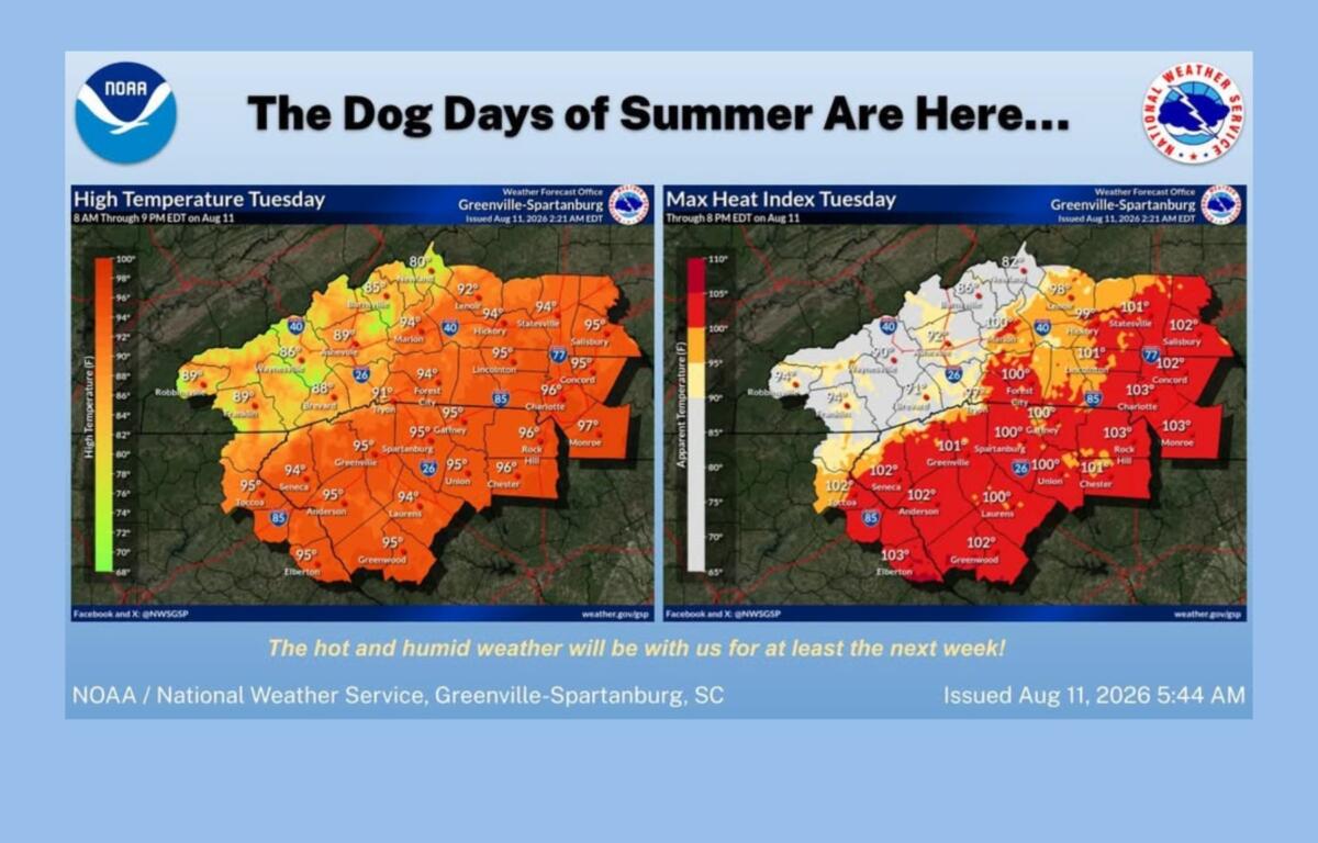
The heat isn’t the only weather concern this week.
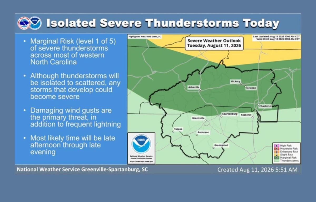
The National Weather Service is warning of a chance for strong thunderstorms across much of Western North Carolina, particularly during the late afternoon and evening.
The area is under a Marginal Risk, or Level 1 of 5, for severe thunderstorms Tuesday. Storms are expected to be isolated to scattered, but those that develop could produce damaging wind gusts and frequent lightning.
Some storms also could bring locally heavy rainfall.
For Asheville, Tuesday’s forecast calls for mostly sunny skies and a high near 90, with a 30% chance of showers and thunderstorms, mainly between 3 and 4 p.m. Overnight, there is another 30% chance of thunderstorms, along with patchy fog and a low around 67.
Wednesday should again reach around 90 degrees, with a 30% chance of thunderstorms late in the day.
Thursday could be the hottest day in Asheville so far this week, with a high near 91 and a 20% chance of afternoon thunderstorms.
Friday is expected to be mostly sunny with a high around 91 and a 30% chance of thunderstorms after 5 p.m.
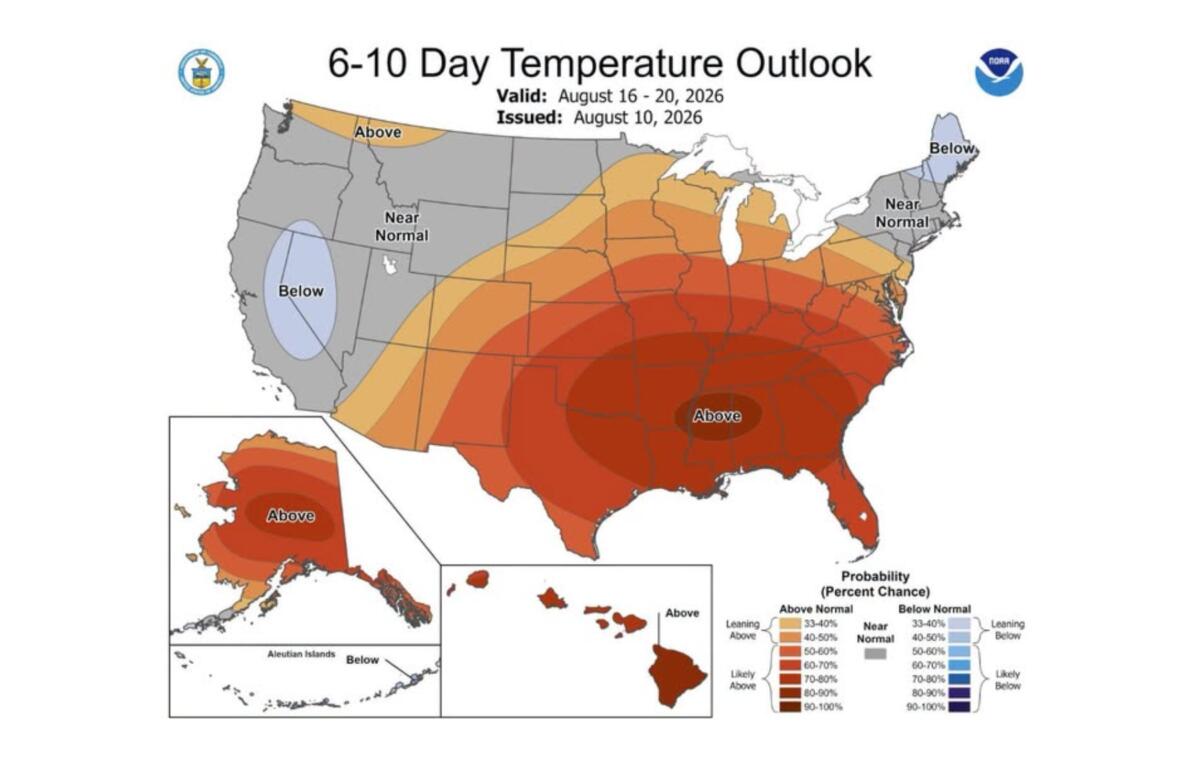
The National Weather Service said hot and humid conditions are expected to continue for at least the next seven days. Some areas farther east could see heat indexes between 100 and 105 degrees Thursday and Friday.
For Western North Carolina, forecasters say afternoon thunderstorms could help keep heat indexes below heat advisory levels in some areas, but the potential for dangerous heat remains.
Residents should continue to monitor the forecast, especially if spending extended periods outdoors.
Staying safe in the heat
Health officials recommend:
- Drink plenty of fluids.
- Take frequent breaks from the heat.
- Limit outdoor activities during the hottest part of the day.
- Stay in air conditioning when possible.
- Never leave children or pets in a parked vehicle.
- Watch for signs of heat-related illness, including dizziness, headache, nausea, weakness and confusion.
The National Weather Service expects the pattern of afternoon showers and thunderstorms to continue into the weekend, with hot and humid conditions lingering into next week.