



ASHEVILLE, N.C. (828newsNOW) — Much of North Carolina is struggling with drought, and forecasters see little chance of rain over the next several days. But Western North Carolina is faring better than much of the state.
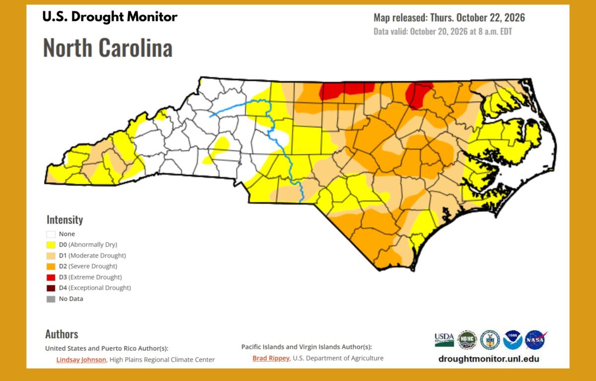
The latest U.S. Drought Monitor map, released Thursday, Oct. 22, shows widespread drought across North Carolina. The National Weather Service in Raleigh reports that nearly 60% of the state is experiencing drought, with almost a quarter in severe drought or worse.
The worst conditions are concentrated in parts of northern and eastern North Carolina, where some areas are experiencing extreme drought.
Much of the Asheville area and central mountains remain free of drought, although portions of the far western mountains are abnormally dry or experiencing moderate drought.
Recent heavy rainfall from the remnants of Tropical Storm Isaias helped ease drought conditions across much of the mountains and foothills. Some areas received several inches of rain, bringing relief after an extended dry stretch.
But the rain has moved out, and another stretch of dry weather is ahead.
Recent brush fire highlights concerns
Even in areas that aren’t experiencing drought, dry vegetation can increase the risk of fires.
A brush fire along Interstate 40 West near the Buncombe-Haywood county line Wednesday afternoon, Oct. 21, sent firefighters into the woods and backed up traffic for miles.
The fire came two days after the scheduled end of a Buncombe County advisory discouraging outdoor burning.
The county’s fire marshal had urged residents to avoid burning through Monday, Oct. 19, because of increased fire danger from high winds. Officials warned that dry grass, fallen leaves and other vegetation could ignite easily and allow fires to spread quickly.
The advisory was not a burn ban, and the cause of Wednesday’s fire has not been established.
Residents planning to burn outdoors can call the county’s Open Burning Hotline at 828-250-6767 to check whether burning is permitted.
The National Weather Service says relative humidity could fall to around 25% Thursday afternoon in parts of northeast Georgia, raising fire concerns there. Winds, however, are expected to remain light.
Cooler temperatures, possible frost ahead
The National Weather Service in Greenville-Spartanburg says high pressure will keep skies mostly clear across Western North Carolina through the weekend and into early next week.
A dry cold front will bring slightly cooler temperatures beginning Friday, with Asheville’s daytime highs falling from around 70 degrees Thursday to the mid-60s Saturday and Sunday.
Overnight temperatures will be chilly enough for frost in some mountain valleys.
Asheville’s forecast calls for lows around 36 degrees Thursday night, 38 Friday night and 35 Saturday and Sunday nights.
Some mountain valleys could see colder temperatures, increasing the chance of frost Saturday and Sunday nights. Frost is also possible in portions of the northern foothills.
Temperatures are expected to run 5 to 10 degrees below normal Saturday before gradually warming early next week.
When could rain return?
For drought-stricken parts of North Carolina, the bigger question is when meaningful rainfall might arrive.
The National Weather Service in Raleigh says there are early signs of a possible change in the weather pattern around Nov. 2-4 that could bring much-needed rainfall.
But that’s still more than a week away, and it’s too early to know how much rain might fall or which areas would benefit.
In Western North Carolina, forecasters expect dry high pressure to linger into the middle of next week, with temperatures gradually returning to normal.
For now, the mountains can expect several more days of sunshine, chilly nights and little chance of rain.