
ASHEVILLE, N.C. (828newsNOW) — Almost six months after Hurricane Helene hit the United States, the National Hurricane Center has released its final report, and the numbers are staggering.
Helene, the most devastating natural disaster in North Carolina history, made landfall in the Florida Big Bend region as a Category 4 hurricane. The storm brought historic flooding, landslides, extreme winds and numerous tornadoes that devastated portions of the southeastern United States and southern Appalachians.
Western North Carolina residents know how bad it was. We see the scars every day.
Below are some numbers from the National Hurricane Center report that show the devastation.
Helene was the deadliest hurricane for the United States since Katrina in 2005, with at least 248 fatalities, including at least 175 direct deaths.
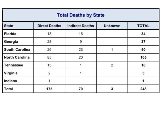
In North Carolina, there were 85 direct deaths, with eight because of wind and 77 from freshwater flooding.
In Buncombe County, flash flooding, river flooding and landslides were directly responsible for at least 37 deaths. Landslides killed 16 people in the Fairview area. In Swannanoa and Black Mountain, at least nine people drowned in the Swannanoa River’s floodwaters, where multiple homes, businesses and roads were destroyed. At least six of the deaths occurred in the city of Asheville, and the exact locations of the other six deaths are unknown.
At least 70 indirect fatalities are linked to Helene: 23 in South Carolina, 20 in North Carolina, 16 in Florida, nine in Georgia, one in Tennessee and one in Virginia. Many of the indirect fatalities were from medical issues, heart attacks, car accidents and incidents during post-storm cleanup.
At least 21 injuries were reported in North Carolina.
At least 865 people were rescued in Western North Carolina, mostly from flood waters.
More than 490 water rescues were performed across Buncombe County.
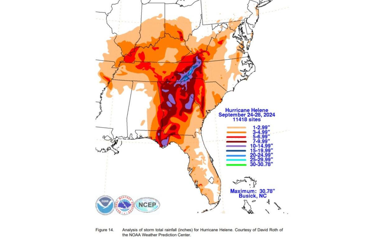
About 20 to 30 inches of rain fell in the mountains of North Carolina.
Helene triggered more than 2,000 landslides — at least 300 were reported in Buncombe County.
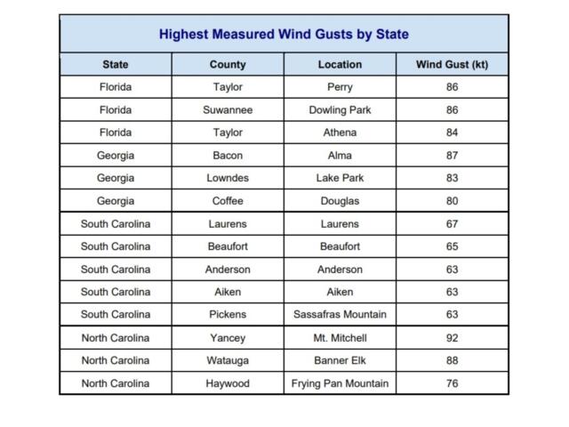
Many mountain peaks in WNC suffered extensive tree falls and damage because of wind gusts. The highest wind gust was near 106 miles per hour at Mount Mitchell.
North Carolina Forest Service estimated about 822,000 acres of forest were damaged or destroyed — about $214 million in damage.
Helene caused extensive damage to Asheville’s water treatment infrastructure, and clean water was not restored to the city until 53 days after Helene passed through the area — though some were without even longer.
Tens of thousands of trees were knocked down across Buncombe County, with hundreds down on homes because of a combination of strong wind gusts and debris flows.
Media reports indicate that more than 560 structures were destroyed and at least 901 structures sustained major damage in Buncombe County, with an additional 8,920 homes/buildings incurring minor or moderate damage.
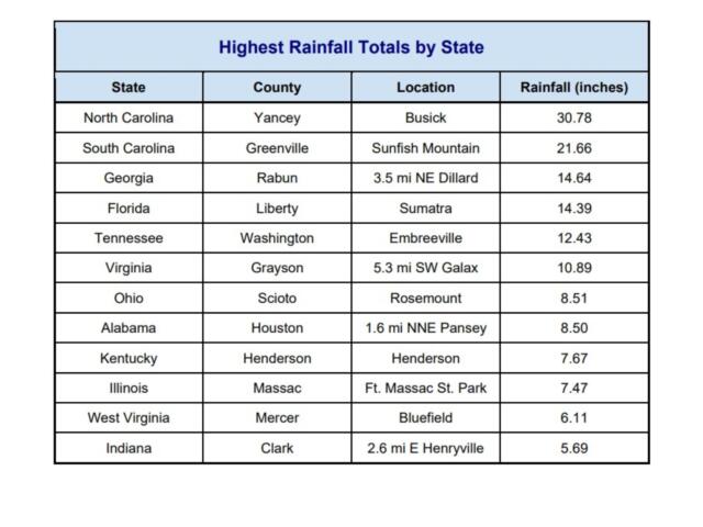
The highest rainfall total in North Carolina was 30.78 inches in Busick (Yancey County).
Some 63 stream or river gauges exceeded record levels.
A total of 34 flash flood emergencies were issued in association with Helene. Two were issued around the Atlanta metro area, with the remaining 32 across the southern Appalachians, with a maximum density over Western North Carolina.
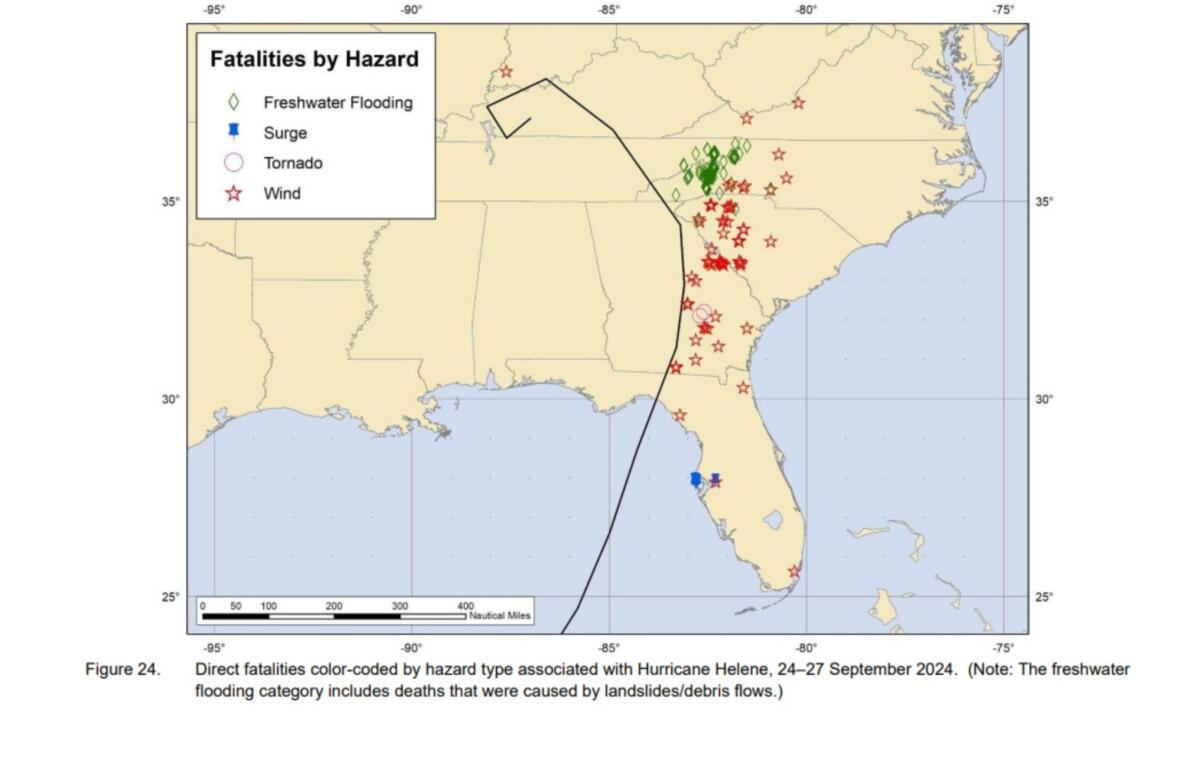
Helene produced 33 tornadoes in the United States while it was a tropical cyclone and six additional tornadoes after it became post-tropical. Of the 33 tornadoes that Helene produced while it was a tropical cyclone, three occurred in Florida, three in Georgia, 21 in South Carolina and six in North Carolina.
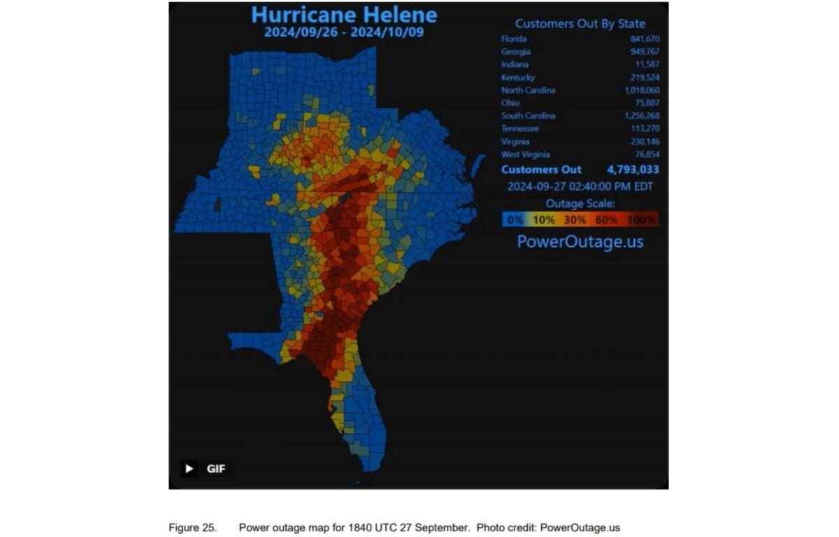
An estimated 7.4 million customers (about 16.2 million people) lost power in the United States on Sept. 26-28 because of Helene. The maximum outage count at any given moment in time was about 4.79 million customers. Florida experienced the largest loss of power with about 1.69 million customers losing service. South Carolina, Georgia and North Carolina experienced an estimated 1.59 million, 1.28 million and 1.18 million outages, respectively.
Power was restored to more than half of Asheville’s customers within a week, although media reports indicate that 25,000 Asheville customers were still without power two weeks after Helene.
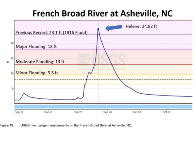
Historic river flooding was particularly damaging to the lower-lying areas of Asheville along the French Broad and Swannanoa Rivers. In the historic Biltmore Village, lower-lying buildings were severely inundated with deep water or swept away. Asheville’s historic River Arts District was largely destroyed.
Significant flooding was reported along the Ivy River in Barnardsville, where multiple structures were inundated.
In the southeast part of Buncombe County, flooding from the Broad River impacted several structures and multiple roads.
More than 20 inches of rain were reported in portions of Henderson County.
Eight direct deaths occurred in Henderson County (five in Hendersonville from freshwater flooding and three from landslides in the Bat Cave area).
According to media reports and county officials, roughly 300 homes/buildings in the county were destroyed, with about 1,400 others incurring major damage.
At least 86 landslides were documented in the county, and numerous roads were damaged or washed out. Hundreds of trees were down on homes due to strong wind gusts.
Impacts in Transylvania County were also significant. Dozens of homes were damaged in Rosman with some structures destroyed after being inundated with several feet of water from the French Broad River.
Flooding also occurred along the Davidson River area of Pisgah National Forest, where several water rescues occurred.
Madison and Yancey counties experienced devastating damage from Helene.
In Madison County, aerial drone footage showed floodwaters from the French Broad River inundating the majority of buildings in downtown Marshall.
Farther downstream, the town of Hot Springs was also devastated. Floodwaters from the river destroyed numerous businesses and critical infrastructure. Water, sewer, electricity and communication systems were heavily impacted.
The French Broad River at Hot Springs set a record crest, surpassing the level from the Great Flood of 1916 by 0.3 feet.
Four people died in Madison County, where numerous water rescues were reported.
Hundreds of homes and buildings were either destroyed or sustained major damage.
In Yancey County, which includes Busick where the largest storm-total rainfall occurred, rivers and their tributaries inundated hundreds of
homes, with some structures destroyed.
More than 200 landslides occurred, damaging or destroying numerous roads.
Media sources indicate that about 1,400 homes/buildings were destroyed in the county while 2,300 others were severely damaged, with an additional 2,000 structures incurring minor to moderate damage.
The Coast Guard performed numerous water rescues.
There were 10 direct fatalities in Yancey County — eight from flooding, one in a landslide and one in a vehicle.
Some rivers, creeks and streams in Mitchell County rose to their highest levels in recorded history, and numerous water rescues took place.
The highest reported rainfall in the county was 23.31 inches.
More than 200 landslides were documented in the southern part of Mitchell County, near the McDowell County line.
Wind gusts knocked down an estimated 100,000 trees in Mitchell County.
One direct death in Mitchell County was due to drowning from the floodwaters of the North Toe River.
All of that adds up to an estimated $78.7 billion in damage nationwide and ranks as the seventh-costliest in U.S. history.
To see the full report, check here.