


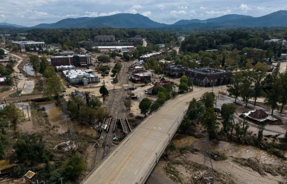

ASHEVILLE, N.C. (828newsNOW) — It did not begin with a hurricane.
By the time Tropical Storm Helene reached Western North Carolina early Friday, Sept. 27, 2024, the mountains had already been soaked by two days of extraordinary rain.
Beginning Wednesday, a stalled frontal boundary helped draw tropical moisture northward ahead of Helene. Rain continued through Thursday as Helene strengthened in the Gulf of Mexico and moved toward the Southeast.
By the time the storm’s rain bands arrived Friday morning, Asheville’s ground was saturated, streams were already swollen and rivers were rising.
Then the water kept coming.
Asheville Regional Airport recorded 13.98 inches of rain from Sept. 25-27, nearly three months of normal precipitation in less than three days. Across the mountains, some locations received 20 inches or more, with a weather station in Yancey County recording more than 31 inches.
The result was catastrophic flooding, record or near-record river levels, widespread landslides, downed trees and power lines and communities cut off from one another.
Here’s how those 48 hours unfolded:
Wednesday, Sept. 25 — The rain begins
Wednesday: A slow-moving frontal boundary settles across the Southern Appalachians as moisture associated with the developing Helene feeds into the region.
It is not yet raining because Helene has arrived. The storm is still hundreds of miles away.
But the setup for the disaster is underway.
By the end of the day: Asheville Regional Airport has recorded 4.09 inches of rain.
Streams in the upper French Broad basin are already running high.
Thursday, Sept. 26 — The mountains keep filling with water
Thursday: The rain continues for much of the day.
The Asheville airport records another 5.78 inches, bringing the two-day total to 9.87 inches.
Elsewhere in the mountains, rainfall totals are even more extreme. More than 9 inches falls in parts of southern Yancey County during the day.
Streams and rivers continue rising as water rushes down from the mountains.
Late Thursday night: Helene makes landfall in Florida’s Big Bend as a Category 4 hurricane.
The storm then races north through Georgia toward Western North Carolina.
Friday, Sept. 27 — Helene arrives
Overnight: Helene moves rapidly toward Western North Carolina.
The ground is saturated. Rivers are already high.
The storm’s tropical rain bands move into the mountains during the early morning hours, adding another burst of extremely heavy rain.
Helene is no longer a hurricane, but it remains a powerful tropical storm.
Winds across the mountains frequently gust between 55 and 70 mph, with stronger gusts at higher elevations. Some mountain locations record gusts approaching or exceeding 100 mph.
Trees begin coming down across roads and power lines.
Electricity begins disappearing across the region.
By Friday morning, Duke Energy was reporting 703,000 customers without power across North Carolina, while crews had already restored hundreds of thousands of outages. The figure was statewide, but it illustrates how quickly Helene’s winds were disrupting the electrical system across the Carolinas.
Friday morning — Swannanoa and Black Mountain
The Swannanoa River and its tributaries rise rapidly.
In the Swannanoa Valley, water begins overwhelming communities along the river.
Homes, businesses and roads are flooded, while emergency responders begin receiving calls for rescues and welfare checks.
The flooding grows rapidly as water pours out of the mountains and into the Swannanoa River.
Friday morning — Asheville becomes increasingly cut off
Flooding spreads through low-lying portions of Buncombe County.
Roads become impassable. Trees and power lines block other routes.
Communications and electricity are increasingly unreliable.
By 11:25 a.m., Blue Ridge Public Radio reported that a power outage was affecting all of its broadcast channels, another indication of how widespread the loss of electricity had become.
As the rain continues, the French Broad and Swannanoa rivers continue rising.
The Asheville airport eventually becomes isolated along with much of the region, while the station’s rain gauge records 13.98 inches since Sept. 25.
3:15 p.m. — Biltmore Village
The Swannanoa River at Biltmore Village reaches a crest of 27.33 feet.
The flooding devastates Biltmore Village and surrounding areas.
Water pours through streets and businesses as the river reaches a level far beyond anything seen during most people’s lifetimes.
5:30 p.m. — River Arts District
The French Broad River at Asheville reaches 24.82 feet, surpassing the previous record of 23.1 feet set during the 1916 flood.
Floodwaters overwhelm portions of the River Arts District, destroying or heavily damaging businesses, studios, homes and infrastructure along the river.
The National Weather Service later describes the flooding as destroying a portion of the River Arts District.
6:15 p.m. — Fletcher
The French Broad reaches 30.61 feet at Fletcher, a record more than 10 feet higher than the previous record of 20.13 feet set in 2004.
Communities along the river continue dealing with rapidly rising water and impassable roads.
8 p.m. — Marshall
The flood wave continues downstream.
The French Broad River at Marshall reaches 21.36 feet.
The record was 22 feet, set during the 1916 flood.
By then, downtown Marshall has suffered devastating flooding. Much of the community’s historic downtown along the French Broad is inundated and heavily damaged.
And the damage continues beyond the rivers
The flooding is only part of the disaster.
Across Western North Carolina, Helene’s winds bring down thousands of trees and power lines. Landslides and debris flows block roads and damage homes.
The National Weather Service reports that some east- and southeast-facing slopes above 3,000 feet experienced canopy loss of 80 percent or more.
By the end of the three-day rainfall event, Asheville has recorded nearly 14 inches of rain.
September 2024 ultimately becomes Asheville’s wettest month on record, with 17.90 inches of precipitation.
But the most important numbers are not just rainfall totals.
They are the times the rivers rose beyond anything most people alive had ever seen:
- 3:15 p.m. — Biltmore Village: 27.33 feet
- 5:30 p.m. — Asheville: 24.82 feet
- 6:15 p.m. — Fletcher: 30.61 feet
- 8 p.m. — Marshall: 21.36 feet
And those numbers tell only part of the story.
For the people living through it, Helene was not a single moment.
It was hours of rain, rising water, failing roads, disappearing power, lost communications and, for many, a desperate struggle to get themselves and their families to safety.
Two years later, the region is still living with the consequences of those 48 hours.