


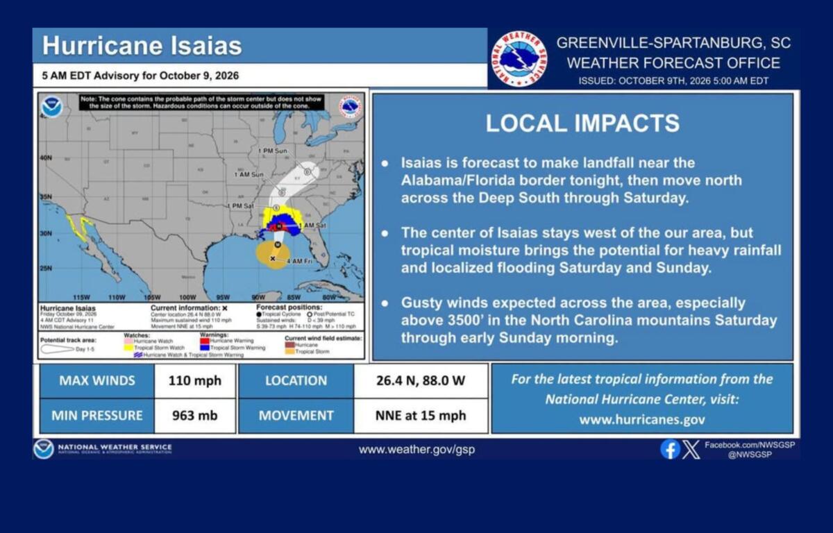

ASHEVILLE, N.C. (828newsNOW) — Another hurricane is headed toward the Southeast, bringing the threat of heavy rain, gusty winds and flooding to Western North Carolina this weekend. But local officials say the region isn’t facing another Helene.
Buncombe County could see 2 to 4 inches of rain from Hurricane Isaias, with heavier amounts possible in Black Mountain, Swannanoa, Broad River and Fairview, according to county officials.
“This storm is not projected to bring widespread flash flooding, major landslides, or catastrophic impacts like those we saw from Helene, but localized impacts are possible,” Buncombe County Government said in a Thursday weather update.
The National Weather Service expects the heaviest rain Saturday afternoon through early Sunday. Some mountain locations, particularly along the Blue Ridge Escarpment and southeast-facing slopes, could receive 4 to 6 inches.
For communities still recovering from Helene’s destruction two years ago, the distinction between the storms is an important one.
Why Isaias is different from Helene
When Helene struck Western North Carolina in September 2024, the ground was already saturated from days of heavy rain. Rivers and streams were swollen before the hurricane’s heaviest rainfall arrived.
Then Helene dumped extraordinary amounts of rain across the mountains, triggering catastrophic flooding and landslides that destroyed homes, businesses, roads and bridges.
Some mountain communities received more than 20 inches of rain during the combined predecessor rainfall event and hurricane.
Isaias is approaching under much different conditions.
The region has experienced a relatively dry stretch, meaning the ground isn’t as saturated as it was before Helene. Forecast rainfall totals are also substantially lower.
The storm’s track is different, too. Isaias is expected to make landfall along the northern Gulf Coast late Friday or early Saturday before moving inland. Its center is forecast to pass well west of Western North Carolina.
That doesn’t mean the mountains will escape its effects.
Tropical moisture moving into the region could produce periods of heavy rain, especially where the mountains force moist air upward and enhance rainfall.
The National Weather Service says localized flash flooding remains the primary concern, particularly along smaller streams, creeks and low-lying roads.
Forecasters also caution that rainfall amounts remain uncertain, and some locations could receive considerably more rain than others.
Rain arrives Saturday, winds could gust near 40 mph
Friday should remain relatively quiet in Asheville, with mostly cloudy skies and a high near 76 degrees.
Showers could begin before daybreak Saturday, becoming widespread through the morning.
Saturday will be cooler, with a high near 64 degrees and a 90% chance of rain. East winds could gust to 34 mph.
Rain will continue Saturday night, when thunderstorms are also possible. The chance of precipitation increases to 100%, with wind gusts reaching 37 mph.
The strongest winds are expected in the higher elevations, particularly above 3,500 feet. Forecasters say gusty conditions could bring down trees or power lines in some locations, although uncertainty remains about how strong the winds will become.
The rain should begin tapering off Sunday morning. Asheville’s forecast calls for a high near 74 and a 70% chance of showers, mainly before 11 a.m.
Drier weather is expected to return early next week.
Asheville, Buncombe County preparing for possible impacts
Asheville and Buncombe County emergency management officials say they’re monitoring Isaias and preparing to respond if conditions worsen.
Asheville’s Emergency Management team is working with the National Weather Service and Buncombe County Emergency Management to track the storm.
“All of our City departments are prepared to respond,” the city said in a Thursday social media post.
City officials said they would provide updates if conditions change and encouraged residents to sign up for AVL Alerts.
Buncombe County also urged residents to prepare for possible disruptions, including having enough emergency supplies to last at least 72 hours.
Officials warned drivers not to attempt to cross flooded roads or drive over downed power lines.
Residents can sign up for BC Alerts by texting “BCReady” to 67283 or visiting buncombenc.gov/bcalerts.
Additional emergency preparedness information is available at buncombeready.org.
Localized flooding remains possible
Although Isaias isn’t expected to produce the widespread destruction associated with Helene, the National Weather Service says the threat of localized flooding shouldn’t be overlooked.
Heavy rain could cause streams and creeks to rise quickly, particularly in areas where rainfall becomes concentrated over a short period.
The greatest rainfall potential is along the Blue Ridge Escarpment and southeast-facing mountain slopes, including areas of the Balsam and Black mountains and the headwaters of the French Broad and Savannah river basins.
Forecasters say confidence is increasing that widespread rain will reach Western North Carolina this weekend, but questions remain about exactly where the heaviest rain will fall.
For now, the forecast calls for a wet, windy weekend with the potential for localized flooding — but not the catastrophic conditions that accompanied Helene.