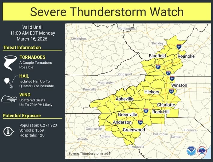

ASHEVILLE, N.C. (828newsNOW) — A severe thunderstorm watch has been issued for Asheville and much of Western North Carolina as a line of strong storms moves through the region Monday morning, forecasters said.
The watch, issued by the National Weather Service, remains in effect until 11 a.m. Monday and includes Buncombe County and several surrounding mountain counties.
Forecasters warn that some storms could produce damaging wind gusts and heavy rainfall as they move through the Asheville area during the morning hours.
According to the National Weather Service Greenville-Spartanburg forecast office, showers and thunderstorms are likely overnight into Monday morning, with the potential for severe storms before 11 a.m. Rain chances remain high through the morning.
Winds from the south could reach gusts up to 31 mph, and rainfall totals of a quarter to a half inch are possible, with higher amounts in stronger storms.
Conditions are expected to change rapidly later in the day as a cold front moves through the mountains. Temperatures in Asheville could fall from the 50s in the morning to around 40 degrees by late afternoon, while winds shift to the northwest.
Behind the front, much colder air will move into the region Monday night. Forecasters say there is a slight chance of snow showers early Monday evening, followed by mostly cloudy skies and lows near 19 degrees with northwest wind gusts up to 40 mph.
Drier weather is expected Tuesday with mostly sunny skies and a high near 39 degrees, followed by a gradual warming trend later in the week. Temperatures are forecast to reach the upper 60s by Friday.