


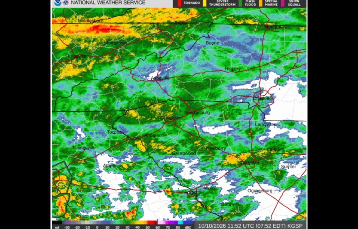

ASHEVILLE, N.C. (828newsNOW) — Rain moved into the Asheville area overnight, and the heaviest downpours are still ahead as the remnants of Isaias bring the threat of flooding, landslides and strong winds to Western North Carolina this weekend.
The National Weather Service in Greenville-Spartanburg says the greatest concern is Saturday afternoon through early Sunday morning, when repeated downpours could cause streams and creeks to rise quickly and flood low-lying roads.
A flood watch remains in effect for much of Western North Carolina until 2 p.m. Sunday.
Most of the region could receive 2 to 4 inches of rain, but some mountain communities could see considerably more. Forecasters say 5 to 8 inches is possible in some locations, particularly along the Blue Ridge Escarpment and in the Black Mountains.
The heaviest rainfall is expected in areas where moist air is pushed up against the mountains, increasing the potential for flooding and landslides.
What to expect in Asheville
Saturday will be wet, windy and cool in Asheville, with a high near 65 degrees.
Showers are expected throughout the day, with thunderstorms possible after 2 p.m. Winds could gust as high as 41 mph, and another half-inch to three-quarters of an inch of rain is expected during the day.
The heaviest rainfall in Asheville may come Saturday night, when another 1 to 2 inches is possible. Showers and thunderstorms are expected to continue overnight, with winds gusting as high as 38 mph and temperatures holding near 59 degrees.
Conditions should begin improving Sunday. Showers remain likely, mainly before noon, but some afternoon sunshine is possible as temperatures climb to around 72 degrees. Winds should ease, although gusts could still reach 24 mph.
The forecast calls for another quarter-inch to half-inch of rain Sunday.
Altogether, Asheville could receive roughly 1¾ to 3¼ inches of additional rain through Sunday, based on the latest forecast. That does not include rain that has already fallen.
Flooding and landslides are concerns
The National Weather Service is paying particular attention to mountain watersheds, including the upper Pigeon River and upper French Broad River.
Forecast rainfall totals in the upper Pigeon River watershed, upstream of Canton, range from 4 to 9 inches, with isolated amounts of 10 to 11 inches possible.
In the upper French Broad River watershed, upstream of Etowah, 4 to 8 inches is forecast, with isolated totals of 8 to 10 inches possible.
Those higher amounts are not expected throughout the Asheville area, but they could lead to flooding along streams and rivers downstream.
Forecasters are also warning of an increased risk of landslides and debris flows, particularly along steep slopes and in areas where Tropical Storm Helene damaged or destabilized the ground in September 2024.
The National Weather Service issued a special statement Friday evening highlighting the potential for landslides in the mountains and foothills.
The concern is greatest in places that receive particularly heavy rain over a short period. Rainfall can saturate the soil, making slopes more susceptible to movement.
The warning does not mean landslides will occur throughout the mountains, but residents near steep slopes, particularly those damaged during Helene, should pay attention to changing conditions and official alerts.
Strong winds could bring down trees
Rain isn’t the only concern this weekend.
A high wind warning remains in effect until 8 a.m. Sunday for mountain elevations above 3,500 feet, where southeast winds could gust as high as 60 mph.
Lower elevations are under a wind advisory, with gusts of 45 to 50 mph possible.
The combination of strong winds and rain-soaked ground could bring down trees and power lines, causing outages.
The National Weather Service says widespread power outages are possible in the higher elevations, while lower elevations could experience isolated outages.
Residents are encouraged to secure outdoor furniture and other loose items, keep phones charged and use extra caution while driving, especially in high-profile vehicles.
Is there a tornado threat?
Forecasters are also monitoring the possibility of isolated severe thunderstorms and brief tornadoes.
That threat remains low and is focused primarily on areas south and east of Interstate 85, including parts of Upstate South Carolina and northeast Georgia.
The greatest potential for severe storms is Saturday evening into the overnight hours, depending on how atmospheric conditions develop.
For Asheville and most of the Western North Carolina mountains, heavy rain, flooding and strong winds remain the primary concerns.
When will the rain end?
There is some encouraging news in the forecast.
The remnants of Isaias are moving inland faster than previously expected, and forecasters say the heaviest rain should begin moving east early Sunday.
Most of the significant weather threats are expected to diminish by Sunday afternoon, although gusty northwest winds could continue across higher elevations Sunday night into Monday.
A few lingering showers are possible in the mountains Monday morning.
After that, drier weather and a warming trend are expected, with temperatures potentially climbing to around 10 degrees above normal by the middle of next week.
Stay informed, not alarmed
For Western North Carolina residents still recovering from Helene, the prospect of another weekend of heavy rain may be unsettling.
But this is a different weather system, and the forecast does not suggest a repeat of the widespread destruction caused by Helene.
The main concerns this weekend are localized flooding, landslides in vulnerable mountain areas and trees or power lines brought down by strong winds.
A flood watch means conditions are favorable for flooding, not that flooding is occurring everywhere.
Drivers should never attempt to cross flooded roads, even if the water appears shallow. Residents near streams, steep slopes or areas previously damaged by landslides should be especially attentive to local warnings.
Weather conditions can change quickly, so residents are encouraged to keep weather alerts enabled on their phones and follow updates from the National Weather Service at weather.gov/gsp.