



ASHEVILLE, N.C. (828newsNOW) — Western North Carolina is about to get another reminder that winter isn’t far away, with mountain snow, gusty winds and some of the coldest temperatures of the season expected heading into the weekend.
The National Weather Service says a strong cold front moving through the region Thursday, Nov. 12, will bring a sharp drop in temperatures and the possibility of accumulating snow along the North Carolina-Tennessee border.
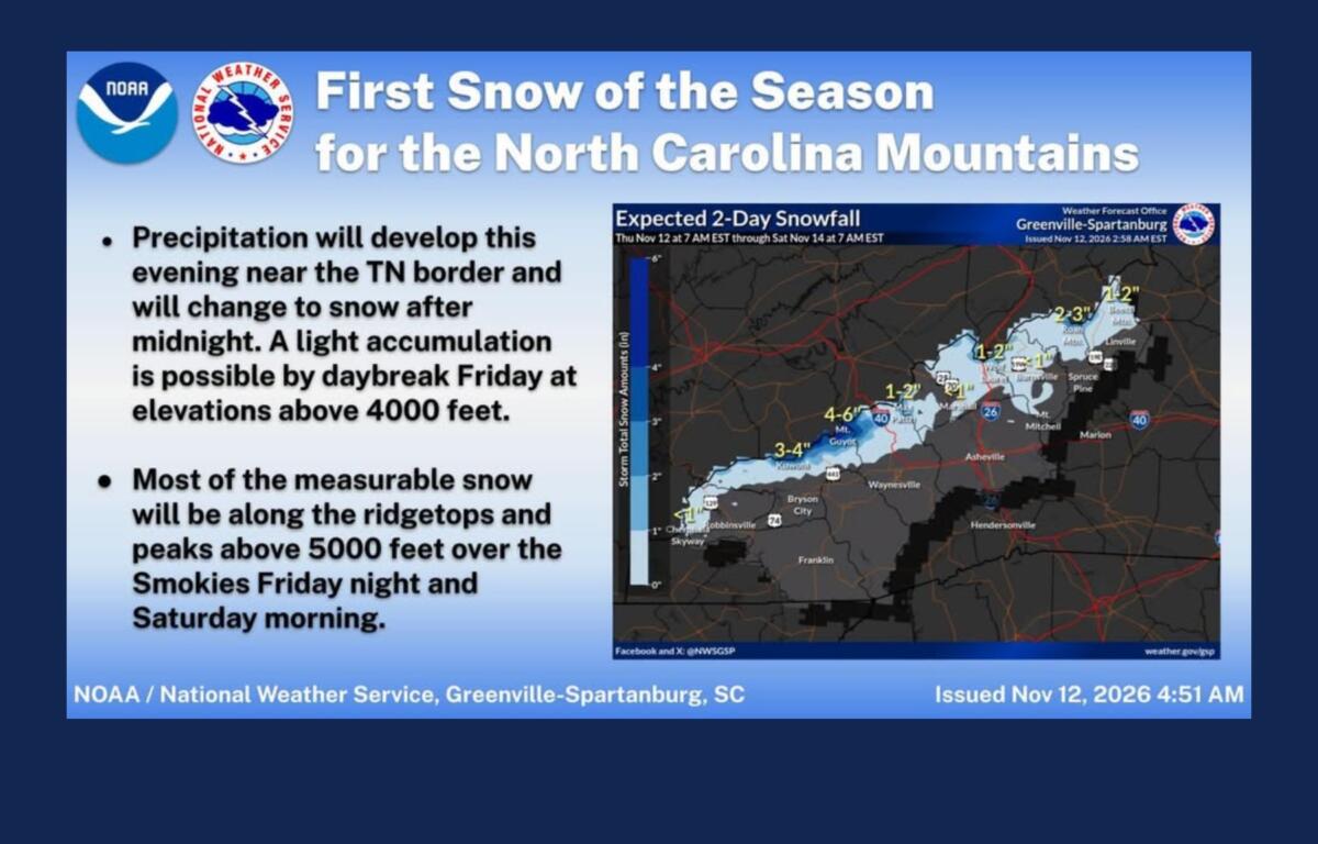
Snow showers could begin late Thursday night and continue into Saturday morning, with the best chances for accumulation in the higher elevations of the Smoky Mountains.
Forecasters expect generally light snowfall along the Tennessee border, with accumulations ranging from a dusting to 3 inches in favored locations. The highest totals are expected in the Smokies, where isolated areas could receive more.
Some light accumulation could develop above 4,000 feet by daybreak Friday, with most measurable snow expected on ridges and peaks above 5,000 feet Friday night into Saturday morning.
The National Weather Service says most locations are expected to receive less than 2 inches, and a winter weather advisory is not anticipated at this time.
Warmer temperatures leading up to the cold front could also limit accumulation, especially when the snow first begins falling.
Could Asheville see snow?
While the best chances for accumulating snow remain near the Tennessee border, Asheville isn’t entirely out of the picture.
The National Weather Service forecast calls for a slight chance of rain and snow showers in Asheville early Friday morning, with temperatures dropping to around 32 degrees overnight.
Local meteorologist Hunter Ward of Ashevillewx says some computer models suggest snow showers could spread beyond the higher elevations Friday afternoon and evening, potentially bringing a brief burst of snow into the Waynesville and Asheville areas.
That possibility remains uncertain, however. The National Weather Service expects most snow showers to stay near the Tennessee border.
Even if flakes reach Asheville, little or no accumulation is expected under the official forecast.
Cold temperatures and gusty winds
For most of Western North Carolina, the cold will be hard to miss.
Asheville is expected to reach about 58 degrees Thursday before temperatures tumble into the lower 30s overnight.
Friday’s high will struggle to reach 46 degrees, followed by an overnight low near 28.
Saturday will be even colder, with a high around 44 degrees and temperatures plunging to approximately 23 degrees Saturday night.
The National Weather Service expects a widespread freeze across the region, with Saturday night likely to be the coldest of the weekend.
Gusty winds will make conditions feel even colder.
Wind gusts could reach 30 mph in Asheville on Thursday, with gusts approaching 28 mph Friday and Saturday.
Along the highest mountain peaks and ridges, gusts could reach 40 to 50 mph.
Forecasters say winds are expected to remain below advisory levels, although that could change.
When will it warm up?
The coldest weather should begin easing Sunday.
Asheville is expected to see sunshine and a high near 52 degrees, although temperatures could fall back to around 25 degrees Sunday night.
The National Weather Service says temperatures are expected to remain generally below normal for mid-November even as the region begins to warm.
Although the weather service stopped issuing seasonal frost and freeze alerts Nov. 11, temperatures are still expected to fall well below freezing this weekend.