


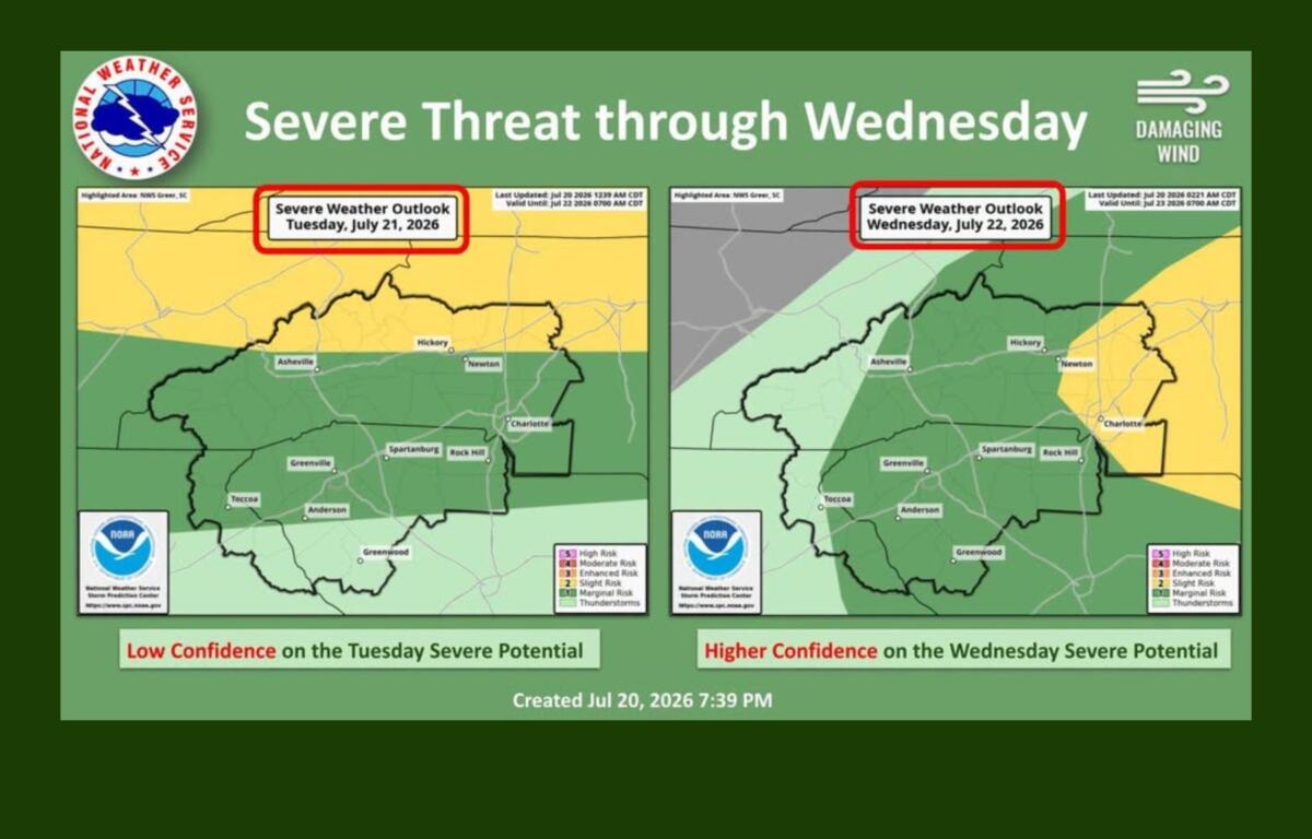

ASHEVILLE, N.C. (828newsNOW) — Western North Carolina could see another round of strong to severe thunderstorms Tuesday afternoon and evening, with forecasters warning that damaging wind gusts are the primary threat, especially across the mountains and foothills.
The National Weather Service in Greenville-Spartanburg said storm coverage Tuesday is expected to be more limited than in recent days, and confidence remains low that widespread severe weather will develop. Even so, a few storms could become severe as they move across the North Carolina mountains and foothills.
Madison County Emergency Management echoed that assessment, saying scattered thunderstorms are expected to develop late Tuesday afternoon and continue into the evening. While some forecast models suggest only isolated storms will form, officials said any stronger storms that develop could produce damaging winds.
The severe weather threat is expected to increase Wednesday as a weak cold front moves into the region.
The National Weather Service said confidence is higher that isolated severe thunderstorms will develop Wednesday afternoon and evening as the front provides more favorable conditions for storm development. In addition to damaging winds, forecasters say localized flooding will become a greater concern because slow-moving storms could repeatedly track over the same areas.
Showers and thunderstorms are expected to remain likely through Thursday as the cold front slowly pushes south, although the overall severe weather threat should diminish. Isolated flooding will remain possible in areas that receive repeated rounds of heavy rain.
Despite the unsettled weather, the approaching front will also bring welcome relief from the recent stretch of hot, humid conditions.
High temperatures Tuesday will climb to around 90 degrees in the Asheville area, while communities outside the mountains are expected to reach the low to mid-90s. Heat index values will remain elevated, although most mountain locations are expected to stay below advisory criteria.
Beginning Thursday, temperatures are forecast to fall well below normal, with afternoon highs in the upper 70s to around 80 degrees through at least Saturday — as much as 10 degrees cooler than average for late July.
The National Weather Service continues to encourage residents to stay hydrated, take frequent breaks in air-conditioned or shaded areas and never leave children or pets unattended in vehicles while the heat persists through Tuesday.
Asheville forecast
Tuesday: A 20% chance of showers and thunderstorms after 3 p.m. Mostly sunny, high near 90.
Tuesday night: A 30% chance of showers and thunderstorms, low around 70.
Wednesday: Showers and thunderstorms likely, with an 80% chance of rain. High near 84.
Thursday: Showers and thunderstorms likely, high near 79.
Friday: A 40% chance of showers and thunderstorms. High near 79.
Saturday: Showers and thunderstorms likely, with an 80% chance of rain. High near 80.
Forecasters encourage residents to monitor the latest forecasts Tuesday and Wednesday, as the timing and intensity of storms may change as the cold front approaches.