




ASHEVILLE, N.C. (828newsNOW) — Summer heat and humidity are settling in across Western North Carolina, with temperatures expected to run above normal through the week and daily chances for afternoon thunderstorms.
The National Weather Service in Greenville-Spartanburg said Monday will be mostly sunny in Asheville, with a high near 89 degrees. A few isolated to scattered thunderstorms are possible across the mountains and foothills during the afternoon and early evening.
The storms aren’t expected to be widespread Monday, but some could become strong, with damaging wind gusts and frequent lightning the primary concerns.
The weather service has placed the northern mountains, northern foothills and northwest Piedmont under a Marginal Risk, or Level 1 of 5, for severe thunderstorms Monday.
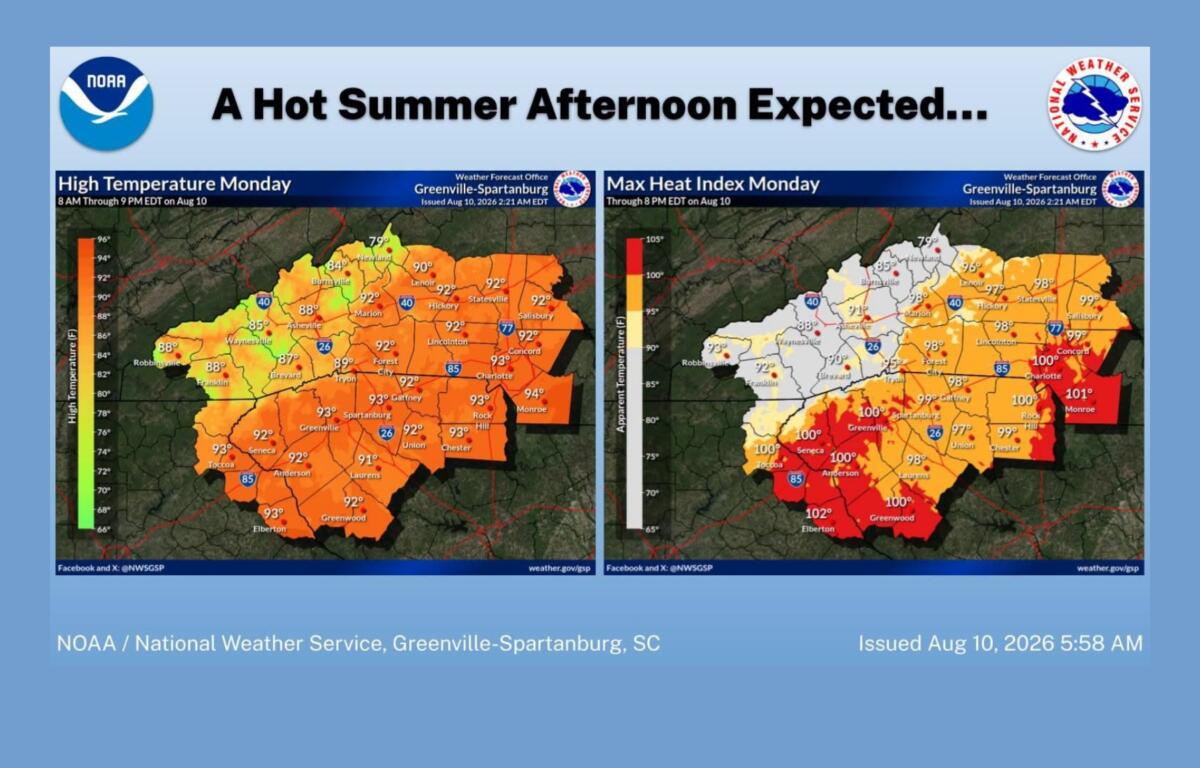
For Asheville, the forecast calls for patchy fog before 10 a.m., followed by mostly sunny skies. Winds will be light, becoming north-northwest around 5 mph in the afternoon.
Patchy fog could return overnight, with temperatures dropping to around 67 degrees.
More heat ahead
The bigger story this week will be the heat.
Temperatures are expected to climb into the upper 80s and low 90s in Asheville through Friday, with even hotter conditions possible in the foothills and Piedmont.
The weather service said some areas of the Upstate and Piedmont could see afternoon heat indexes between 98 and 103 degrees each day beginning Monday.
For Asheville, the forecast calls for highs near 90 degrees Tuesday, 89 Wednesday and 90 Thursday and Friday.
The hottest conditions could arrive later in the week, with the weather service saying some areas could see heat indexes reach around 105 degrees Thursday or Friday.
Storm chances continue
Thunderstorm chances will remain in the forecast throughout the week, generally developing during the afternoon and evening.
Asheville has a 30 percent chance of showers and thunderstorms after 4 p.m. Tuesday and Wednesday. The chance increases to 40 percent Friday afternoon.
While most storms should remain isolated to scattered, forecasters are watching the potential for more organized storms Tuesday and Wednesday. Those storms could bring damaging winds and locally heavy rainfall.
Forecasters said confidence remains low on exactly where any organized storms may develop, but the potential is enough to keep an eye on the forecast as the week progresses.
For now, the forecast calls for a typical stretch of hot, humid August weather: plenty of sunshine, warm afternoons and a daily chance of storms.
Asheville forecast
- Monday: Mostly sunny, high near 89. Patchy fog before 10 a.m. A few afternoon storms possible in the region. Low around 67 tonight.
- Tuesday: Mostly sunny, high near 90. A 30% chance of showers and thunderstorms after 4 p.m. Low around 67.
- Wednesday: Mostly sunny, high near 89. A 30% chance of showers and thunderstorms after 4 p.m. Low around 68.
- Thursday: Partly sunny, high near 90. Low around 69.
- Friday: Partly sunny, high near 90. A 40% chance of showers and thunderstorms after 2 p.m.