



ASHEVILLE, N.C. (828newsNOW) — Fall colors are still hanging on in the North Carolina mountains, but winter made an early appearance Saturday morning.
Snow fell at some of the highest elevations in Western North Carolina on Oct. 17, including Mount Mitchell, where the National Weather Service reported a burst of snow as temperatures dropped below freezing.
The National Weather Service reported the season’s first snow at elevations above 5,000 feet along the Blue Ridge Parkway.
At Mount Mitchell, the highest peak east of the Mississippi River at 6,684 feet, the temperature was 29 degrees Saturday morning, with a wind chill of just 19 degrees.
The snow came on the heels of a strong cold front that sent temperatures tumbling across Western North Carolina.
Forecasters said Saturday’s highs would be about 20 degrees cooler than Friday’s, even with sunshine returning during the afternoon.
And the coldest weather is still to come.
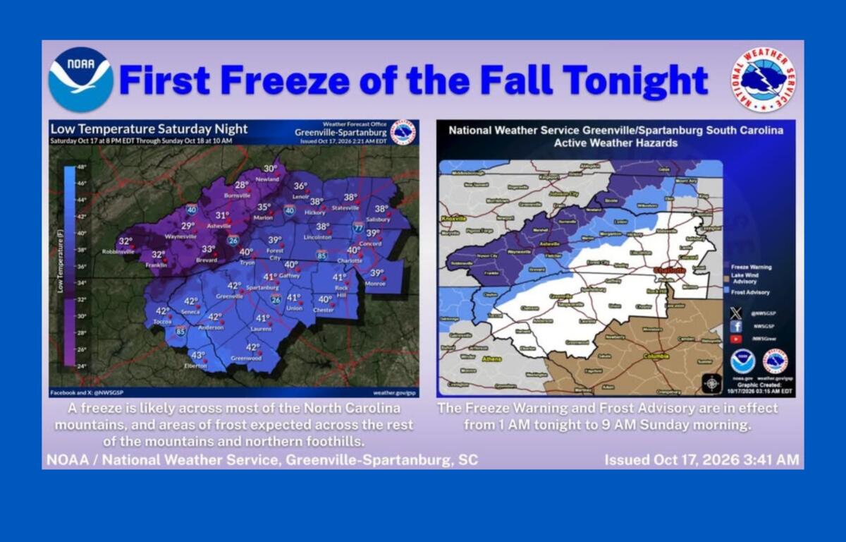
The National Weather Service has issued a freeze warning for much of the North Carolina mountains from 1 to 9 a.m. Sunday, Oct. 18.
The warning includes Buncombe, Haywood, Madison, Yancey, Mitchell, Avery, Swain, Graham and Macon counties, along with portions of Jackson County.
Temperatures could fall into the upper 20s and lower 30s overnight, cold enough to damage or kill sensitive plants and crops.
A frost advisory is also in effect from 1 to 9 a.m. Sunday for Henderson, Transylvania, McDowell, Burke and Caldwell counties, along with Alexander County and mountain areas of Rutherford and Polk counties.
Asheville could see widespread frost Sunday morning.
The city was expected to reach a high near 57 degrees Saturday, with north winds gusting up to 28 mph. Temperatures will fall to around 33 degrees overnight, with frost developing after 3 a.m.
Sunday should bring sunshine and a high near 63 degrees, but widespread frost is expected before 9 a.m.
Forecasters are urging residents to bring sensitive plants indoors or cover them, disconnect garden hoses and protect exposed outdoor plumbing. Pets should also have a warm place to stay overnight.
The cold snap comes as fall foliage at elevations above 5,000 feet is already moving past peak color, according to the weather service.
But the early taste of winter won’t last long.
Temperatures are expected to gradually climb over the next several days, returning to near-normal levels by Tuesday or Wednesday.
Another round of frost or freezing temperatures is possible Sunday night, although forecasters expect conditions to be slightly warmer.
Dry weather is expected across Western North Carolina through much of next week.