



ASHEVILLE, N.C. (828newsNOW) — The worst of the rain from Isaias should be over by Sunday afternoon, but Western North Carolina isn’t out of the woods just yet.
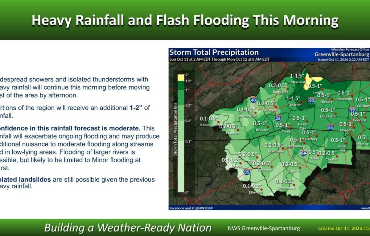
Another 1 to 2 inches of rain could fall Sunday morning, Oct. 11, adding to flooding that developed overnight and raising the risk of more landslides across the mountains.
The National Weather Service in Greenville-Spartanburg said the heaviest rain should move east of the region later Sunday morning, with skies clearing across much of the area during the afternoon.
A flood watch remains in effect until 2 p.m. Sunday for much of Western North Carolina.
An isolated thunderstorm is also possible before the rain moves out, but the greater threat of severe weather is expected farther east.
McDowell County reports flooding, landslides
McDowell County was among the hardest-hit areas overnight, with more than 7 inches of rain reported in the Sugar Hill, Zion Hill and Crooked Creek communities.
Other parts of the county received 4 to 6 inches, according to a 5:17 a.m. Sunday update from McDowell County Emergency Management.
The National Weather Service confirmed two landslides in the county, one near the county line off N.C. 226-A and another on Bear Wallow Road.
The Woodlawn-Sevier Volunteer Fire Department reported additional mudslides, landslides and flooding in its service area.
Emergency officials urged residents to avoid unnecessary travel while water levels remain high. Drivers should watch for debris and never attempt to cross a flooded road.
Asheville breaks rainfall record
Saturday was the wettest Oct. 10 on record at Asheville Regional Airport.
The airport recorded 3.81 inches of rain, more than double the previous daily record of 1.50 inches set in 2020, according to the National Weather Service.
Greenville-Spartanburg International Airport also broke its daily rainfall record, recording 3.12 inches Saturday.
Those totals are for Saturday alone, not the entire storm.
French Broad River expected to reach minor flood stage
A flood warning remains in effect through Monday morning for the French Broad River at Grove Bridge Road in Blantyre, affecting Henderson and Transylvania counties.
The river was at 15 feet and rising at 1:30 a.m. Sunday. The National Weather Service forecast early Sunday that it would crest at 17.5 feet later in the day, above the minor flood stage of 16 feet.
At that level, flooding is expected to affect farmland along both sides of the river and boat access areas at Grove Bridge Road and Crab Creek Road.
Water could also reach the shoulders of River Road near Big Willow Road.
The river is expected to drop below minor flood stage late Sunday evening, although the warning remains in effect until Monday morning.
Current river levels and forecasts are available through the National Water Prediction Service.
Sunshine and warmer temperatures on the way
After a soggy weekend, the forecast offers some welcome relief.
The remnants of Isaias are moving northeast toward the central Appalachians, and a cold front should push the remaining widespread rain out of Western North Carolina by Sunday afternoon.
A few light showers could linger along the Tennessee border, but forecasters don’t expect them to cause additional flooding.
Winds will remain gusty in the mountains, particularly at higher elevations, where northwest gusts of 25 to 35 mph are expected Sunday night into Monday.
By Tuesday, the weather should be much quieter.
Dry conditions are expected for most of the workweek, with temperatures climbing well above normal Tuesday through Thursday.
Another cold front late in the week could bring temperatures back closer to normal or slightly below.
Flash flood sirens sounded near Chimney Rock overnight
The heavy rain also prompted emergency warnings Saturday night in Rutherford County.
Rutherford County Emergency Management activated flash flood warning sirens in the Fall Creek area north of Chimney Rock as water levels rose in the Rocky Broad River corridor.
During the warning, officials urged residents and visitors near the river to move to higher ground and stay alert for rapidly changing conditions.
Chimney Rock and Lake Lure are still recovering from the devastating flooding caused by Hurricane Helene in September 2024.
McDowell County also experienced flash flooding overnight, with emergency officials reporting high water across portions of the county early Sunday.
Although the heaviest rain is expected to end Sunday morning, rivers and streams may remain high after the skies clear.
Emergency officials are urging people to stay away from flooded roads, obey barricades and use caution in areas where saturated ground could give way.