



ASHEVILLE, N.C. (828newsNOW) — Western North Carolina faces a double threat this weekend as Isaias brings heavy rain and strong winds that could cause flash flooding, landslides and power outages.
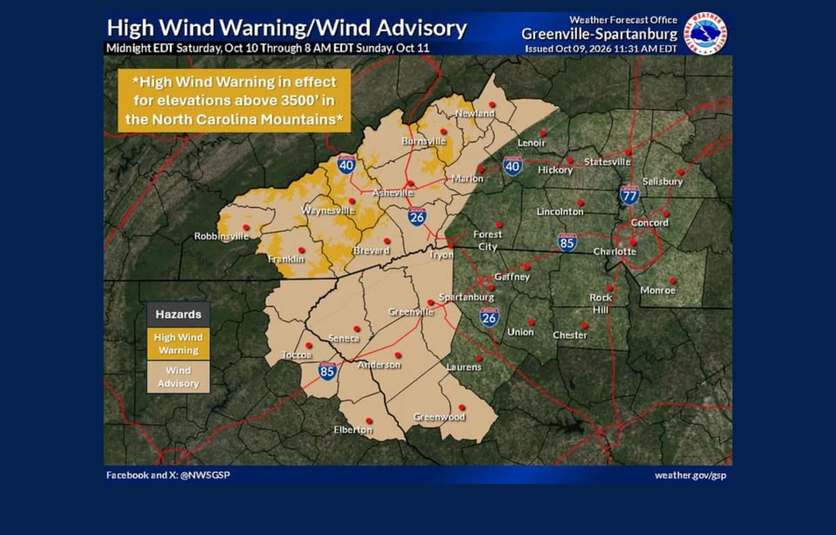
The National Weather Service issued a flood watch Friday afternoon for Asheville and 13 other mountain counties, along with a high wind warning for higher elevations and a wind advisory for lower elevations.
The flood watch takes effect Saturday morning and continues through Sunday afternoon. The wind alerts begin at midnight Friday and remain in effect until 8 a.m. Sunday.
Isaias is expected to weaken as it moves north through the Mid-South, passing west of the western Carolinas. Even without a direct hit, the storm could bring dangerous conditions to parts of the mountains.
Winds could reach 60 mph in higher elevations
The strongest winds are expected above 3,500 feet, where gusts could reach 60 mph. Forecasters expect damaging winds to bring down trees and power lines, with widespread power outages possible in higher elevations.
Lower elevations are under a wind advisory, with gusts of 45 to 50 mph expected. Those winds could blow around unsecured outdoor items, break tree limbs and cause isolated power outages.
Residents should secure outdoor furniture and other loose items before the winds arrive. The Weather Service also recommends staying on lower floors and away from windows during the strongest winds.
Driving could be difficult, particularly for trucks, RVs and other high-profile vehicles.
Heavy rain raises flooding, landslide concerns
The flood watch covers Avery, Buncombe, Burke, Caldwell, Haywood, Henderson, Jackson, Macon, McDowell, Mitchell, Polk, Rutherford, Transylvania and Yancey counties.
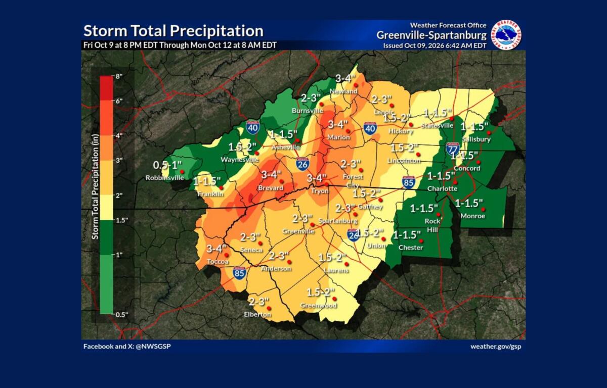
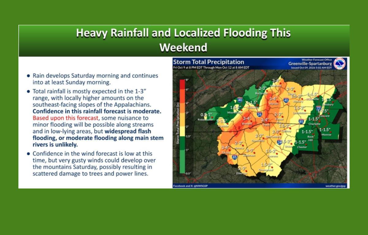
Rain could begin before dawn Saturday, although the first showers are expected to be relatively light. The rain should pick up during the day, with the heaviest downpours expected Saturday afternoon through early Sunday morning.
Forecasters are especially concerned about the Blue Ridge Escarpment, where the mountains can intensify rainfall. That includes areas near the North Carolina-South Carolina border west of Interstate 26 and the steep terrain stretching from Saluda toward Grandfather Mountain.
Heavy rain could send creeks and streams out of their banks, flood low-lying roads and make some crossings impassable. Flash flooding could also develop in places that don’t normally flood.
Landslides and rockslides are another concern, particularly in steep mountain communities.
The Weather Service says rainfall exceeding 5 inches in similar storms has been associated with an increased risk of landslides. That doesn’t mean 5 inches is forecast this weekend, but it highlights the danger heavy rain can pose in the mountains.
People living on steep mountainsides or in coves at the base of mountains, especially near streams, should be prepared to leave if rising water, moving earth or falling rocks threaten their homes.
Forecasters also have identified a small risk of severe thunderstorms as the storm moves through the region.
What residents should know
A flood watch means conditions are favorable for flooding, but flooding is not certain. A flash flood warning is more urgent and means dangerous flooding is occurring, imminent or expected to begin shortly.
With heavy rain and strong winds expected during the same period, residents should keep phones charged, secure outdoor belongings and pay attention to changing weather conditions.
Avoid driving through flooded roads, and consider postponing travel on mountain roads during periods of heavy rainfall or strong winds.
The flood watch remains in effect through Sunday afternoon, while the high wind warning and wind advisory are scheduled to expire at 8 a.m. Sunday. Additional warnings could be issued as conditions develop.